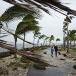
Large swathes of central Mexico were hit by torrential rains as Arlene, the first tropical storm of the Atlantic hurricane season, touched down near coastal sand barrier Cabo Rojo Thursday.
Mexican officials advised communities in the storm’s path to evacuate and state oil monopoly Pemex was on alert for threats to its refineries and other facilities. However, these were not expected to be hit directly.
Arlene made land south of Tampico, where Pemex has its 190,000-barrel-per-day Madero refinery. Pemex said the refinery was operating as usual but it had taken the precaution of securing tankers and smaller boats at the adjoining port.
Still, Mexicans facing Arlene’s initial onslaught were struck by the power of the rainfall.
“The downpour is so strong, it’s the first time I’ve ever seen rains like this,” said Juana Manrique, 23, from the coastal fishing town Tuxpan in the state of Veracruz.
“There’s no one in the streets. I’m going back to lock myself in the house and not leave for anything,” she added.
Mexico’s government extended its Gulf Coast hurricane watch from La Cruz southward to the beach area Barra de Nautla in Veracruz, about 200 miles [320 kms] south of Tampico.
Bigger inland Pemex refineries in Salamanca, producing 245,000 bpd, and Tula, with 315,000 bpd capacity, were also in the storm’s forecast path.
Mexico is a top oil exporter to the United States and almost all its exports are shipped from the Gulf of Mexico.
DOWNGRADE
The U.S. National Hurricane Center downgraded its earlier hurricane warning for Arlene to a tropical storm warning.
“Tropical storm conditions will continue to spread inland through portions of eastern Mexico today,” the center said.
Mexican authorities said the storm was expected to be 435 miles |nearly 700 kms] wide and drench parts of central Mexico by Saturday, affecting areas as far away as the Pacific coast. Around 20 states were likely to be hit, authorities said.
Moving west, Arlene had maximum sustained winds of 65 mph [104 kph] and higher gusts, the NHC said. The storm was 45 miles |72 kms] northwest of Tuxpan and 45 miles south-southeast of Tampico on Thursday morning, the center said.
Strong winds and rain of 4 to 8 inches [10.16 to 20.32 cms] are expected to batter the eastern states of Tamaulipas, Veracruz and eastern San Luis Potosi and reach Mexico City by Friday. In mountainous areas as much as 15 inches [38.1 cms] may fall, the NHC said.
“These rains could cause life-threatening flash floods and mudslides,” the center said.
Mexico’s northeastern Atlantic coast is popular with local tourists for its beaches but many poor coastal towns lack flood defenses.
“Everyone in an area which is at risk is urged to seek safe ground,” Interior Ministry rescue official Laura Gurza said on Wednesday.
The rains could bring some relief to farmers planting sugar cane, sorghum and fruit trees in the area who have been suffering from a prolonged dry spell.
Hurricane Beatriz, the second tropical storm of the Pacific season, hit Mexico last week but did no major damage.
(Writing by Dave Graham and Rachel Uranga; Editing by Doina Chiacu)
Topics Catastrophe Hurricane Mexico
Was this article valuable?
Here are more articles you may enjoy.


 Former Congressman Charged After Collision with State Trooper in Florida
  FBI Says Chinese Hackers Preparing to Attack US Infrastructure
  Survey Shows Majority of Florida, California Homeowners Seeing Higher Insurance Costs
  Uncertainty Keeps Prices Up; No Prior-Year Loss Development: Travelers

