
Catastrophe modeling firm AIR Worldwide estimated Tuesday evening that insured losses from Hurricane Sandy to onshore properties in the U.S. would be in the range of $7 billion to $15 billion.
AIR’s insured loss estimate includes wind and storm surge damage to onshore residential, commercial and industrial properties and their contents, automobiles, and time element coverage (additional living expenses for residential properties and business interruption for commercial properties).
AIR’s estimate range is higher than the one published earlier by another catastrophe modeling firm, Eqecat, which forecast that Sandy was likely to cause anywhere from $5 billion to $10 billion in insured losses, with the overall economic losses in the range of $10 billion to $20 billion.
AIR’s estimate suggests industrywide insured losses from Sandy could potentially be more than three times as much as the losses from last year’s Irene.
Meanwhile, Risk Management Solutions has suggested Sandy’s insured losses would likely top Irene’s estimated $4.3 billion insured losses but the firm has not yet released its loss estimate range as of Tuesday night.
AIR Worldwide said its loss estimates reflect:
• Insured physical damage to property (residential, commercial, industrial, auto), both structures and their contents;
• Additional living expenses (ALE) for residential claims;
• For residential lines, estimates reflect AIR’s view that insurers will ultimately pay 10% of modeled storm surge damage as wind losses;
• For commercial lines, insured physical damage to structures and contents, and business interruption directly caused by storm surge, assuming a 10% take-up rate for commercial flood policies (Note: Other flood losses are not modeled or reflected in estimates); business interruption losses include direct and indirect losses for insured risks that experience physical loss;
• For the automobile line, estimates reflect AIR’s view that insurers will pay 100% of storm surge damage;
• Demand surge.
AIR’s loss estimates do not reflect:
• Losses paid out by the National Flood Insurance Program;
• Losses resulting from the compromise of existing defenses (e.g., natural and man-made levees);
• Losses from the flooding of tunnels and subways;
• Losses to uninsured properties;
• Losses to infrastructure;
• Low-level losses in states distant to the storm’s center that have resulted from the interaction between Sandy and another frontal system to the west;
• Losses from extra-contractual obligations;
• Losses from hazardous waste cleanup, vandalism or civil commotion whether directly or indirectly caused by the event;
• Other non-modeled losses;
• Losses for U.S. offshore assets and non-U.S. property.
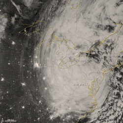
Sandy made landfall as a post-tropical cyclone at around 8:00 p.m. Oct. 29, 2012, 5 miles southwest of Atlantic City, N.J.
At landfall, the storm had a central pressure reading of 946 mb and estimated sustained winds of 80 mph, said Tim Doggett, principal scientist at AIR Worldwide. Actual wind recordings included gust wind speeds of 90 mph in Islip, N.Y. and Tomkinsville, N.J. Other readings included an 84 mph gust at Plum Island, N.Y., 83 mph in Cuttyhunk, Mass., and 76 mph in Groton, Conn.
According to AIR, hours before landfall, Sandy’s central pressure reached a low of 940 mb — a pressure reading that would usually be associated with more powerful hurricanes—but it remained a Category 1 storm. This was due to Sandy’s enormous size; tropical storm-force winds reached nearly 950 miles across, and hurricane-force winds extended 175 miles.
This allowed for a more gradual wind speed gradient between the eye and the outer bands, which mitigated the wind speed. Sandy’s diameter made it the largest Atlantic hurricane on record in terms of the span of tropical storm-force winds, according to AIR. The storm affected areas as far north as Toronto and west to the Great Lakes. Chicago reported wind gusts up to 60 mph and waves in Lake Michigan exceeded 24 feet.
Sandy’s diameter was nearly twice the size of other massive hurricanes including Katrina (2005) whose diameter was 435 miles, Isabel (2003) whose diameter was 575 miles, and Isaac (2012) whose diameter was 450 miles, said Doggett.
He said the huge radius helped to keep the winds at Category 1 intensity, and allowed the storm to interact with the an approaching disturbance in the jet stream that resulted in severe weather across a wide swath of the eastern United States, including blizzard conditions in the higher elevations of the Appalachians.
As of Tuesday, Oct. 30, Sandy is still a post tropical cyclone with maximum sustained wind speeds of 45 mph. The storm is expected to move across southern Pennsylvania and turn north into western New York State later Tuesday night. By Wednesday, the storm’s center is expected to reach Canada.
Sandy brought New York and other major cities along the Atlantic coast to a halt. A record storm surge (13.88 feet at the Battery in lower Manhattan) produced significant flooding particularly in the low-lying areas near the East River and several towns on the Jersey Shore. The Brooklyn-Battery tunnel and seven subway tunnels under the East River remain flooded as of Tuesday, and commuter rail service is suspended, effectively shuttering business in New York City.
Along the entire east coast and well inland, heavy rainfall softened the soils allowing trees to be loosened and topple more easily onto homes, cars and power lines. Sandy also shuttered the nation’s capital. The National Weather Service predicted the worst flooding of that region since 1996. High wind warnings extend across Washington, Virginia, and Maryland, which are all in declared states of emergency.
Topics Catastrophe USA Natural Disasters New York Profit Loss Flood Hurricane
Was this article valuable?
Here are more articles you may enjoy.
 Progressive Gains as Drivers Shop Around for Auto Insurance—Again
  Marsh McLennan Agency to Buy Fisher Brown Bottrell for About $316M
  USAA to Lay Off 220 Employees
  Investment Funds File New Suits Over Lighthouse Insurance Collapse in 2022