
Hurricane Irene is likely to cause more insured losses in the Bahamas than 1999’s devastating Hurricane Floyd, catastrophe modeler AIR Worldwide said Thursday, even as the storm increasingly tracks toward a weekend landfall in the greater New York City area.
Floyd was one of the strongest tropical cyclones on record when it hit the Bahamas more than a decade ago, and it later prompted one of the largest evacuations in U.S. history as well. AIR said Irene’s path through the Bahamas made greater damage than Floyd more likely.
More detailed estimates are expected Friday, as the storm passes over the islands and begins to take aim at the Eastern United States.
While Irene has a long way to travel, and a great deal of uncertainty still remains, more and more computer models on Thursday suggested the storm would come very close to New York City or perhaps even pass directly over it.
The last hurricane known to have made landfall in the city proper was in 1821, causing a 13 feet storm surge that inundated the entirety of lower Manhattan. City officials said they are considering evacuations.
Beyond New York City and Long Island, the storm looks set to hit large swaths of New England with heavy rains and wind, potentially including Boston.
“If it follows its exact tracking you may not see exact hurricane-force winds in the Manhattan area, it may be more strong tropical storm-type stuff,” said James Aman, senior meteorologist at Earth Networks. “Certainly the south shore of Long Island seems to be the area that’s most under the gun right now. A lot of (Northeast U.S.) areas will see high-end tropical storm conditions here by the end of the weekend.”
Aman said there is a chance, based on the current tracks, that a Category 1 hurricane could make landfall Sunday afternoon right around the area of JFK Airport, one of the country’s most important.
One expert in disaster modeling said it would be hard for New York, Rhode Island, Connecticut and Massachusetts to escape significant damage.
“I would be surprised if New England completely gets by without any damage on this one,” said Peter Dailey, director of atmospheric science for AIR, one of the three companies insurance companies rely on to model their exposure to disasters.
Dailey said storm surge was a particularly important issue for the Northeast, with low-lying areas susceptible to flooding if the hurricane pushes the waters up substantially.
Much will depend, he said, on timing — tides are expected to be especially high on Sunday night, so if the storm hits then, flooding could be exacerbated.
Shares in property insurers were about 3 percent lower on Thursday, a sharper decline than the broader markets, as the storm moved closer. Among those most exposed are AIG, Chubb Allstate and Travelers.
(Reporting by Ben Berkowitz, editing by Matthew Lewis)
Topics Catastrophe USA New York Hurricane
Was this article valuable?
Here are more articles you may enjoy.
 California Sees Two More Property Insurers Withdraw From Market
  Wildfires Are Upending Some of the Safest Bets on Wall Street
 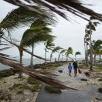 Survey Shows Majority of Florida, California Homeowners Seeing Higher Insurance Costs
  Chubb to Acquire MGA Healthy Paws From Aon