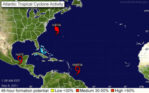
It’s a busy time of year for the National Hurricane Center in Miami. The NHC is currently following one hurricane – Katia, and two tropical storms – Maria and Nate.
Katia is following the previously forecast track between the east coast of the U.S. and Bermuda. Although the storm is still a category one hurricane on the Saffir-Simpson scale, with sustained winds of 87 mph, 141 km/h, and gusts up to 107 mph, 172 km/h. The NHC said hurricane-force winds extend outward up to 90 miles, 150 kms, from the center, and tropical-storm-force winds extend outward up to 230 miles, 370 kms.
Although, on the forecast track neither Bermuda nor the U.S. are directly threatened, the NHC warned that surf and large swells generated by Katia “will continue to affect most of the east coast of the United States, Bermuda and east-facing beaches of the Bahamas during the next couple of days. These swells are likely to cause life-threatening surf and rip current conditions.”

It is moving toward the west “near 23 mph, 37 km/h, and this general motion is expected to continue today, followed by a gradual turn toward the west-northwest and a decrease in forward speed on Friday,” the NHC said. “On the forecast track the center of Maria would approach the Leeward Islands Friday or Friday night.
According to the 5-Day forecast track, unless the storm shifts significantly northward, or breaks up, it could come ashore along the U.S. east coast sometime next week.
Meanwhile, another Tropical Storm, Nate, has formed in the Gulf of Mexico. It is presently about 130 miles, 205 kms, west northwest of Campeche, Mexico, and about 200 miles, 320 kms, northeast of Coatzacoalcos, Mexico.
Maximum sustained winds are around 45 mph, 75 km/h. Tropical-storm-force winds extend outward up to 105 miles, 165 kms, from the center. The NHC expects “some strengthening during the next 48 hours.”
The NHC described Nate as following an “erratic course.” It could come as far north as southern Texas, but will likely do so somewhere along the east coast of Mexico, where tropical storm warnings have been issued.
“Nate is expected to produce total rain accumulations of 2 to 4 inches [5 to 10 cms] with isolated maximum amounts of 8 inches [20.3 cms] over the Mexican States of Campeche, Tabasco and Southern Veracruz,” the NHC said. “A storm surge will raise water levels by as much as 1 to 3 feet [0.3 to 1.0 meters] above normal tide levels along the immediate coast in the warning area.”
Source: National Hurricane Center
Topics Catastrophe USA Natural Disasters Windstorm Hurricane Mexico
Was this article valuable?
Here are more articles you may enjoy.


 California Chiropractor Sentenced to 54 Years for $150M Workers’ Comp Scheme
  Cargo Owners in Baltimore Disaster Face ‘General Average’ Loss Sharing, MSC Says
  Supreme Court Makes It Easier to Sue for Job Discrimination
  AIG Sues Newly Launched Dellwood Insurance and Its Founders

