View this article online: https://www.insurancejournal.com/news/midwest/2019/06/06/528660.htm
The flooding Missouri and Mississippi rivers tested sandbag fortifications on June 5 as surging waters making their way downstream rose to some of their highest levels in more than two decades in parts of Missouri.
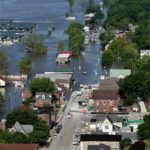
The Missouri River had been projected to start falling in Jefferson City but first rose above its forecasted crest, causing road crews to start sandbagging along a major highway that carries traffic into the state’s capital city.
The floodwaters blocked multiple city streets leading up to the Capitol, which sits on a bluff, caused some businesses to close and left state employees with the choice of trudging through waters in waders to get to and from their remaining parking lots or else taking shuttles from remote locations.
Tony Anderson put on rubber boots to walk through the flooded sidewalks and streets to get to his Capitol-area coffee shop, which he had to close to customers.
“We hit another high crest,” said Anderson, later adding with some concern: “We may be in for a long haul.”
The Missouri River, which already had inundated the city’s airport, was at its highest level in Jefferson City since 1993.
Dozens of downstream Missouri River agricultural levees already have been overtopped or breached. That’s caused water to rise in the cemetery in the small town of Hardin, where more than 1,000 bodies washed away in the massive 1993 flooding.
In St. Louis, the Mississippi is expected to crest Friday, but on Wednesday river levels already were the second highest on record, behind the historic 1993 flood. The city itself is well protected by a flood wall, but sandbagging was under way in suburban Bellefontaine Neighbors. And residents of one apartment complex near the suburb of Affton were evacuated because of related flooding along the River Des Peres.
More than $9 million in national flood insurance claims already have been paid to 213 Missouri property owners since flooding began this March.
But that’s expected to rise significantly, because about 425 claims remain open and numerous others are expected to be filed after floodwaters recede and people can assess the damage to their homes and businesses.
When Missouri last experienced significant flooding in 2017, the National Flood Insurance Program paid more than $75 million to 1,382 Missouri property owners.
More than 700 miles (1126.49 kilometers) of the Missouri, Mississippi and Illinois rivers are closed to navigation across the nation’s midsection. That includes more than 200 miles (321.85 kilometers) of the upper Mississippi River and a stretch of the Missouri River stretching from Kansas City to St. Louis, according to the U.S. Coast Guard.
At Truman Reservoir in western Missouri, water levels have never been higher, and the roadway across the dam has been closed, the U.S. Army Corps of Engineers said. The agency plans to increase releases from the reservoir after the crest on the Missouri River passes Hermann in the eastern part of the state.
The Missouri Highway Patrol also urged drivers to be cautious with more than 340 roads closed statewide. In a video tweeted Tuesday, the patrol showed what can happen if the barricades are ignored. The trooper’s dashcam captured a driver speeding past him and a road closed barricade on U.S. 40 in Boone County last week.
The video shows water spraying up as the car enters the floodwaters and then the car begins to float. The trooper waded out to the car and helped the driver to safety, the tweet said.