
The Caribbean Catastrophe Risk Insurance Facility (CCRIF) has been gearing up to face the 2011 Atlantic Hurricane Season by “providing assistance to Caribbean nations to prepare for the tropical cyclones that are expected to affect the region.”
The CCRIF said the preparation “takes two forms. The first is that CCRIF has made available its Real-Time Forecasting System (RTFS) to all its members. The RTFS is a storm impact forecast tool which provides users with real-time hurricane hazard and impact information and can support users in effective disaster preparedness and response, evacuation decision making, planning for pre-positioning of equipment and supplies as well as in contingency planning to secure critical infrastructure and operations prior to a hurricane. This is the fourth year in which the RTFS has been made available by CCRIF. A total of 146 persons have registered for access to the RTFS this year, a 60 percent increase over last year.
“The second form of assistance provided by CCRIF to its members relates to the provision of training in the effective use of the RTFS. During July, in collaboration with the Caribbean Institute of Meteorology and Hydrology (CIMH) and Kinetic Analysis Corporation (KAC), CCRIF provided two sets of training on the RTFS.
“Seventy-eight persons from 18 countries in the Caribbean region participated in the two-day online training course (delivered through the newly established CCRIF online training site) entitled, Understanding the Real-Time Forecasting System – a Practical Course Designed to Strengthen Caribbean Governments’ Disaster Response and Mitigation Capacity.
“The training focused on improving participants’ understanding of hurricane risks, provided them with general information on what forecasting is and what it involves, while introducing its limitations. Equal importance was placed on exposing participants to various topics including: the key features of the RTFS product; understanding the RTFS modeling platform; application of the RTFS; selecting locations to be included in the RTFS product; and an introduction to the use of Google Earth, the platform through which the RTFS product is delivered.
“Participants included personnel from disaster management departments and meteorological offices, ministries of planning, agriculture and finance as well as a number of international development agencies working in countries across the region in disaster risk management. Participants felt that the training was a success and in the evaluation completed by them, 94 percent indicated that the course was very good with over 80 percent of them indicating that the course content as either excellent or very good.”
The CCRIF also said it “believes that this training – as well as providing access to the RTFS – is timely and represents significant progress in disaster risk management for the region.” Dr. Simon Young of the CCRIF Facility Supervisor Team commented: “The RTFS will no doubt enable our countries to be better prepared to manage the potential impact of the storms during this year’s Hurricane Season.”
In light of the damages caused in prior years, and the predictions that this hurricane season will be a busy one, the preparations are an important part in the association’s efforts to minimize the loss of life and property damage in the region.
According to Ms. Ekhoseuhi Iyahen, of the CCRIF Facility Supervisor team and facilitator on the RTFS course, “Many of our members have used the RTFS and can attest to its value. In fact, when Hurricane Tomas struck CCRIF members Barbados, Saint Lucia and St Vincent & the Grenadines in October 2010, prior preparations using real-time storm impact forecasts from the RTFS played a positive role in reducing damage levels in these countries and also helped to minimize loss of life during the storm.”
Source: CCFRIF
Was this article valuable?
Here are more articles you may enjoy.
 JPMorgan Client Who Lost $50 Million Fortune Faces Court Setback
  FBI Says Chinese Hackers Preparing to Attack US Infrastructure
  Trump’s Bond Insurer Tells Judge Shortfall Is ‘Inconceivable’
 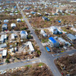 4,800 Claims Handled by Unlicensed Adjusters in Florida After Irma, Lawsuit Says