
According the catastrophe modeling firm AIR Worldwide, strong winds and heavy rainfall from Typhoon Halong have already arrived on Japan’s Daito Islands (about 320 km [200 miles] east of Okinawa), with reports of maximum sustained surface winds of approximately 139 km/h [86.37 mph] and central pressure of 945 mb.
AIR’s report said: “On Friday (local time) rain and wind bands from Typhoon Halong are expected to rake Okinawa. Halong is forecast to continue on a northward track along the western periphery of a subtropical ridge and the eastern side of Kyushu, and make landfall by Saturday (local time) in western Shikoku as a storm equivalent to a strong Category 1 or a minimal Category 2 hurricane on the Saffir-Simpson scale.
“After being downgraded from Super Typhoon status earlier this week, Halong is forecast to maintain its current intensity prior to landfall and could cause significant wind and flood damage across Japan, where many areas recently experienced record rainfalls.”
AIR Worldwide senior scientist Dr. Kevin Hill said: “Destructive wind gusts between 135 and 160 km/h [84 and 100 mph] are expected to slam the southern coasts of Kyushu and Shikoku and western Honshu Saturday (local time).
“Flooding and mudslides, however, could be an even bigger concern, as torrential rain from both Tropical Storm Nakri and a stalled frontal boundary has saturated soils. In western parts of Honshu, several locations set all-time records for three-hour rainfall early Wednesday (local time), recording up to 140 mm [5 ½ inches] of rain. A location in Kochi Prefecture measured a record 1,186 mm [3.891 feet] in 72 hours, according to JMA.”
AIR noted, however, that “Tokyo will escape Halong’s worst winds but is forecast to receive heavy rainfall and wind gusts over the weekend. Saturday night (local time) will see the strongest winds, at which time sporadic power outages and tree damage are possible.”
Dr. Hill forecast that after passing Tokyo, “the storm will still be capable of producing potentially flooding rain and winds of 65 to 95 km/h [40 to 60 mph] across the northern Japanese islands of Honshu and Hokkaido and the coast of Russia’s Maritime Territory and southern Sakhalin Island.”
According to AIR, the “majority of the residential buildings in Kyushu and Shikoku consist mostly of wood-frame construction. At the expected wind speed levels, these structures may experience moderate to high cladding and roofing damage. For engineered buildings, such as reinforced concrete and steel buildings, expected structural damage is very low to none. Commercial building cladding and roof coverings could experience moderate levels of damage.
“The vulnerability of buildings to flood damage varies by construction type. For a given flood depth, a residential wood-frame building is expected to sustain more damage than a residential masonry building. Concrete construction is less vulnerable to flood than steel or masonry. Commercial and apartment buildings usually have stronger foundations than residential buildings, and are thus better able to resist flood loads.”
AIR also explained that “water damage to machinery and contents drives most flood loss. Because damage is usually limited to the lower stories of a building, high-rise buildings will experience a lower damage ratio—the repair cost compared to the total replacement value of the building—than low-rise buildings because a smaller proportion of the building is affected.
In addition the report points out that “flood insurance does not exist as a standalone policy in Japan. Instead, property owners can opt to purchase flood coverage as part of a standard fire insurance policy. In typical Japanese flood policy coverage, a specified payout is made only when actual damage falls within a specified range of loss.”
Source: AIR Worldwide
Topics Catastrophe Natural Disasters Flood Japan
Was this article valuable?
Here are more articles you may enjoy.
 JPMorgan Client Who Lost $50 Million Fortune Faces Court Setback
 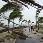 Survey Shows Majority of Florida, California Homeowners Seeing Higher Insurance Costs
  California Sees Two More Property Insurers Withdraw From Market
  Marsh McLennan Agency to Buy Fisher Brown Bottrell for About $316M