
The flooding that has inundated low-lying communities and farmland for miles along the Upper and Lower Mississippi River is due to a large, slow-moving storm system that was spawned nearly a month ago.
“The flooding began when a critical weather pattern brought tornadoes, hail, damaging winds and large quantities of precipitation over the Mississippi and Tennessee Valleys,” said Dr. Boyko Dodov, principal scientist at catastrophe modeling firm AIR Worldwide. “This large, slow-moving system, spanning a period of almost a month, and encompassing several rainstorm events, has contributed to record accumulations of precipitation and major flooding in these regions.”
Over the past few weeks, AIR says, a strong high pressure ridge has persisted over the eastern U.S., blocking the propagation of the cold front that developed behind it. Meanwhile, the trough over the middle portion of the country has allowed for a significant amount of warm moist air to be transported from the South into the middle Mississippi, upper Arkansas and lower Ohio Valleys, resulting in severe weather and significant precipitation in these areas. This type of blocking pattern, also called an Omega block, has the jet stream positioned in a quasi-stationary position, which prevents the normal west-to-east movement of surface storms and fronts and permits weather persistence over large areas of the country.
According to the experts at AIR, the present weather set-up has similarities to the pattern that developed over the central U.S. in June of 1993—the year of another enormous Mississippi River flood. That year, a trough at high levels of the atmosphere became established over the western part of country, allowing for the low-level winds to move unstable warm, moist air from the Gulf of Mexico north, where it converged with the cold dry air moving south from Canada. This large-scale air mass interaction resulted in wave after wave of rainstorms that eventually soaked the Mississippi River basin.
According to Munich Re, the insured losses in 1993 were $1.27 billion, which AIR estimates would amount to $2.6 billion today after accounting for exposure growth and inflation. Meanwhile, the losses in 1993 in the National Flood Insurance Program (NFIP) were $273 million, which AIR estimates would amount to $559 million today after accounting for exposure growth and inflation.
The Federal Emergency Management Agency records approximately 5,646,000 NFIP policies in place last year (2010), up from roughly 4,369,000 flood policies in place a decade ago.
According to the National Oceanic and Atmospheric Administration’s (NOAA) National Climatic Data Center, some areas of the country received up to 20 inches of rain during April. That is nearly half their normal annual precipitation. Six states (Illinois, Indiana, Kentucky, Ohio, Pennsylvania, and West Virginia) had the wettest April on record.
Floods were not the only danger in April. The month had 875 reports of tornadoes that caused more than 350 deaths, according to preliminary reports. The National Weather Service expected the confirmed tornado count to exceed 600, which is a record for any month. There were more than 2,000 reports of hail damage and more than 3,200 wind damage reports, with most of the damage occurring from the southern and central Plains to the Atlantic coast. Tornadoes were observed on two-thirds of the days of the month, with the biggest tornado outbreaks reported on the 14th-16th and 25th-27th.
Presently, the southward moving bulge of river water (known as the flood crest) has left considerable damage in its wake, including in Memphis, where the river came close to reaching record height last Tuesday; it crested at 47.85 feet early Tuesday morning, just under a foot below the record (48.7 feet) set in 1937 when another massive flood inundated 20 million acres of farmland in the region. AIR’s Dodov said that at its height Tuesday, the river was moving at 2 million cubic feet per second and was about three miles wide—roughly three times wider than normal.
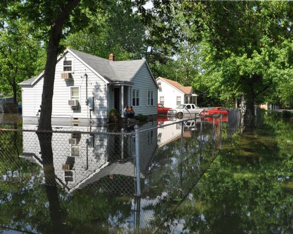
Nearby, large expanses of farmland were completely inundated. The water level in Memphis began to recede Wednesday night, down about two inches from the peak height reported Tuesday.
The National Weather Service predicts that floodwaters in the region should begin to withdraw sometime next week.
To the northwest of Memphis, in Missouri, around 100,000 acres of cropland were left flooded by the bloated river. Farmland in the state was turned to swamp after the Army Corps of Engineers detonated sections of a nearby levee there last week in an effort to save local towns. Elsewhere, the flooding stopped barge traffic on the Ohio River, a Mississippi tributary.
To the south, in Vicksburg, Mississippi, floodwater crashed over a 100-year old levee yesterday, Thursday, flooding 12,000 acres of farmland. The river is not actually expected to crest here until May 19, when it could reach 57.5 feet, according to the Corps of Engineers. “That is about 1.5 feet above the record height for Vicksburg, established in 1927. While the majority of levees in this region have been performing well so far, a breach here is still a concern; should it happen, it could send a massive surge of floodwater onto the Mississippi Delta, a flat area of farmland and small towns,” said Dodov.
In Louisiana, meanwhile, the floodwaters are threatening oil refineries, as well as residential areas west of the river. Officials in the state are taking measures to relieve pressure from levees to protect Baton Rouge, New Orleans and residences and refineries in between the two cities.
Workers trying to block floodwaters from affecting Baton Rouge—where the river is expected to crest to 47.5 feet on Monday, May 23rd—have raised the lower portions of a levee there. The Army Corps may also open the Morganza Spillway, which is only opened when 1.5 million cubic feet per second of water flow by the gauge at Red River Landing in northern Pointe Coupee Parish. If the spillway is opened, it’ll mark the first time it has been used since 1973. However, if the spillway were not opened, New Orleans may be at risk from levee breaks and flood waters that would result in significant damage.
Sources: AIR Worldwide, NOAA
Topics Flood Agribusiness Ohio Mississippi
Was this article valuable?
Here are more articles you may enjoy.
 Two-Thirds of Independent Agencies Plan to Increase AI Use This Year, Survey Says
  CFC Owners Said to Tap Banks for Sale, IPO of £5 Billion Insurer
  Sompo Receives Regulatory Approvals to Acquire Aspen Insurance in $3.5B Deal
  Florida Regulators Crack the Whip on Auto Warranty Firm, Fake Certificates of Insurance