
The 8:00 a.m. AST bulletin from the National Hurricane Center in Miami placed the season’s latest tropical storm, Shary, around 220 miles (355 kms) south–southwest of Bermuda.
The storm, which coalesced from a tropical depression last night, packs maximum sustained winds of 40 mph (65 k/hr). The NHC said “a turn toward the north with a decrease in forward speed is expected later today, followed by a turn toward the northeast tonight.
“On the forecast track the center of Shary is expected to pass near or to the east of Bermuda tonight.”
The storm may strengthen slightly, before it is expected to weaken over the weekend. “Tropical-storm-force winds extend outward up to 105 miles (165 kms) mainly to the north of the center,” said the NHC. “Shary is expected to produce total rain accumulations of 1 to 3 inches [1.6 to 4.8 cms] over Bermuda.”
The NHC is also tracking another “strong tropical wave” off the coast of the Southern Windward Islands, which is estilmated to have an 80 percent chance of developing into a tropical storm in the next few days.
Source: National Hurricane Center
Was this article valuable?
Here are more articles you may enjoy.
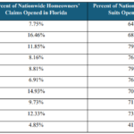 Florida’s Share of Claims Lawsuits Now About Half of 2020 Numbers, Data Show
  Tropical Storm Watches Posted Across Florida’s Panhandle Region
  Models Stripped of Insurance Cover for Club’s Unauthorized Use of Their Images
  Lloyd’s of London Says Former CEO Neal Breached Compliance Rules