
Sandy has strengthened to a strong category 2 hurricane prior to landfall on the Cuban coast, after crossing over Jamaica as a cat 1 hurricane. The system is forecast to remain a hurricane (cat 1) as it passes through the Bahamas later this evening and throughout tomorrow.
The storm made landfall on the southeastern coast Jamaica, 5 miles east of Kingston, late Wednesday as a category 1 hurricane on the Saffir-Simpson Hurricane Wind scale, having intensified from a tropical storm prior to landfall.
According to the National Hurricane Center (NHC), on Thursday, the center of Hurricane Sandy was located just inland over southeastern Cuba, 10 miles north-northwest of Santiago de Cuba and 50 miles west-northwest of Guantanamo. At this time, maximum sustained winds of 110 mph were recorded, still the equivalent of a strong category 2 hurricane. Sandy is still a large storm with hurricane and tropical storm force winds extending outwards up to 30 miles and 140 miles from the center, respectively.
As of the NHC 06:00 UTC advisory, Sandy was moving to the north-northeast at 15 mph, though the official NHC forecast has Sandy shifting to track north-northwest through Friday, before turning towards the northeast beyond this time. On this forecast track the center of Sandy will continue track across Cuba, before reaching the Bahamas later today, taking approximately 24 hours to pass through the Bahamas. The NHC official forecast track is to the center of the model track guidance envelope and there is generally good agreement between the models for the track path over the next 72 hours, though beyond this time there is more uncertainty with the models diverging.
Beyond 72 hours the NHC is forecasting Sandy to track to the northeast parallel to the U.S. coast (around 250 miles offshore) – importantly the NHC forecast is to the east of the ECMWF, NPGS and GFDL models, reflecting the uncertainty in the extended forecast.
Under the NHC forecast Sandy is expected to begin weakening as it interacts with land as it continues to track over eastern Cuba, though is expected to remain a category 1 hurricane as it passes through the Caribbean in a region of low to moderate wind shear, weakening to a tropical storm as the system tracks north encountering cooler waters. The majority of models are calling for Sandy to begin weakening, though the uncertainty in the intensity forecast is reflected in the spread of the model intensity guidance from becoming a weak category 3 hurricane to completely dissipating within the forecast period.
Hurricane force winds are currently affecting southeastern Cuba, with hurricane warnings in effect for Jamaica, southeastern Cuba and the majority of the Bahamas (including the Ragged Islands, excluding the remaining southeastern islands). Tropical storm warnings are in place for the remaining Bahamian islands, as well as Haiti and the southeastern Florida coastline.
Sandy is forecast to bring heavy rain to the central Caribbean, total rain accumulations of 6 to 12 inches, with isolated maximum accumulations of 20 inches possible, which may produce life threatening flash floods and mudslides. Accumulations of 3 to 5 inches are expected in the Bahamas. A storm surge of 1 to 3 feet above normal tides is possible along the coasts of Jamaica, 4 to 7 feet in southeastern Cuba, and as much as 5 to 8 feet in the Bahamas.
Hurricane Sandy caused significant damage to areas in eastern Jamaica, with numerous reports of damage to homes and infrastructure, including bridges and roads. Up to 70% of Jamaica was without power on Wednesday evening, and schools are remained closed on Thursday. One fatality has been reported, and over 1000 people are staying in shelters. Unofficial reports indicate that western Jamaica was spared major damage from Sandy.
RMS will continue to monitor the system and will update accordingly.
Source: Risk Management Solutions
Was this article valuable?
Here are more articles you may enjoy.
 North Carolina Adjuster and Son Charged With Embezzlement in Roof Jobs
  GM Ends OnStar Driver Safety Program After Privacy Complaints
 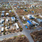 4,800 Claims Handled by Unlicensed Adjusters in Florida After Irma, Lawsuit Says
  Why New York’s Attorney General Objects to Trump’s Bond Insurer