
Tropical Storm Nicholas will pass near or just offshore the coasts of northeastern Mexico and south Texas this morning, and move onshore along the coast of south or central Texas late this afternoon or evening, the National Hurricane Center has warned.
The storm’s maximum sustained winds are near 60 mph (95 km/h) with higher gusts. But it is expected to strengthen today and Nicholas could reach the northwest Gulf coast as a hurricane. The hurricane center said Nicholas should weaken on Tuesday and Wednesday as it moves over land.
The storm is threatening as parts of Louisiana are still suffering the effects of Hurricane Ida that struck two weeks ago.
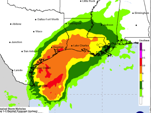
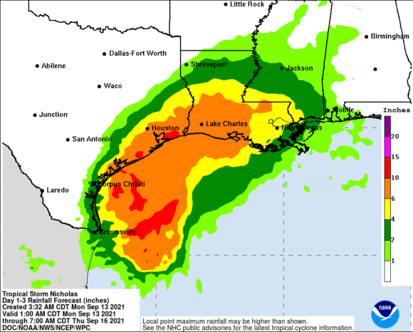
Tropical-storm-force winds extend outward up to 115 miles (185 km) from the center. South Padre Island, Texas, reported a wind gust to 45 mph (72 km/h). Nicholas is expected to produce storm total rainfall of 8 to 16 inches, with isolated maximum amounts of 20 inches, across portions of the middle and upper Texas coastal areas through the middle of the week. Across the rest of coastal Texas into southwest Louisiana rainfall of 5 to 10 inches is expected. This rainfall may produce areas of considerable flash and urban flooding, especially in highly urbanized metropolitan areas. Additionally, there is the potential for isolated minor to moderate river flooding.
The combination of a dangerous storm surge and the tide will cause normally dry areas near the coast to be flooded by rising waters moving inland from the shoreline. The areas affected could include Port O’Connor to San Luis Pass Texas, including Matagorda Bay; Rutherford Beach, La., including Galveston Bay; Baffin Bay, Corpus Christi Bay, Aransas Bay and San Antonio; Intracoastal City, La.
The deepest water will occur along the immediate coast in areas of onshore winds, where the surge will be accompanied by large and dangerous waves.
Tropical storm conditions are expected to first reach the coast within the warning area in northeastern Mexico and southern Texas this morning, making outside preparations difficult or dangerous. These conditions will spread northward within the warning area through tonight. Hurricane conditions are possible in the Hurricane Watch area as early as this afternoon. Tropical storm conditions are possible within the watch area by tonight or early Tuesday.
A tornado or two will be possible today into tonight across the Texas coast.
Swells generated by Nicholas will continue affecting portions of the northwest Gulf coast through Tuesday. These swells are likely to cause life-threatening surf and rip current conditions.
Topics Catastrophe Texas Natural Disasters Louisiana Windstorm
Was this article valuable?
Here are more articles you may enjoy.
 Tropical Storm Watches Posted Across Florida’s Panhandle Region
  Mapfre to Acquire Safety Insurance for $1.54 Billion in Cash Deal
  London Broker Howden Plots Giant Capital Raise on IPO Path
  Walmart Removes Four Taylor Farms Salads as Recalls Spread