29 Million Flood Risk Properties Lie Outside Official Flood Zones: CoreLogic December 6, 2017 An estimated 23 percent of residential and commercial properties in the U.S. are at high or moderate risk of flooding...
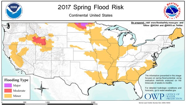
NOAA: North Dakota at Highest Risk for Spring Flooding March 16, 2017 Northern North Dakota – the Souris River, Devils Lake and the northernmost reaches of the Red River – has the...
How Flood Risk in U.S. Is Changing: Increasing in North, Decreasing in South December 30, 2016 The risk of flooding in the United States is changing regionally, and the reasons could be shifting rainfall patterns and...
City in Virginia Proposes Changes to Flood Insurance Rate Maps November 15, 2016 Norfolk officials are urging residents to take notice of proposed changes to federal flood insurance rate maps in the wake...
Sompo Canopius Partners with UK’s SSBN for US Flood Models, Hazard Maps February 12, 2016 Sompo Canopius AG has entered into a license agreement with SSBN, which will provide it with flood models and hazard...
Flood Claims to Hit U.K. Insurers’ 2015 Earnings: A.M. Best January 5, 2016 Flooding in the final month of 2015 will put pressure on the earnings of U.K. property insurers, according to a...
AIR Analyzes Typhoon Koppu’s Heavy Flooding Impact on the Philippines October 20, 2015 A report from catastrophe modeling firm AIR Worldwide highlights “widespread flooding, landslides, wrecked roads and bridges, downed trees, and power...
Gap Between Insured & Economic Losses Offers Business Opportunities: AIR September 18, 2015 A huge global gap between disaster-related insured and economic losses presents a growth opportunity for P/C carriers, AIR Worldwide determined...
Aon Benfield Launches Canada Flood Model to Help Manage Exposures May 18, 2015 Impact Forecasting, Aon Benfield’s catastrophe model development team, has developed a fully probabilistic flood model for Canada to help insurers...
Willis Re Introduces Suite of Flood Analytics for Canada Insurance Market March 20, 2015 Willis Re, the reinsurance division of Willis Group Holdings plc, has unveiled a new suite of flood solutions offering analytical...