
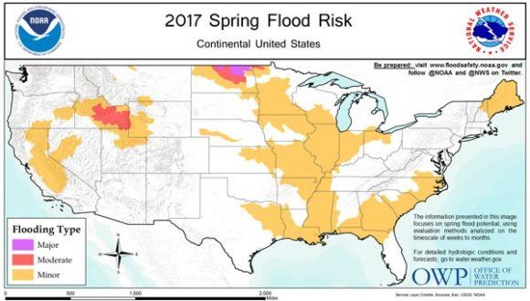
Northern North Dakota – the Souris River, Devils Lake and the northernmost reaches of the Red River – has the greatest risk of major flooding this spring, while moderate flooding is possible over southern Idaho in the Snake River basin, according to NOAA’s Spring Outlook.
“If you’re in northern North Dakota, or in the Snake River basin in Idaho, prepare for moderate to major flooding this spring,” said Tom Graziano, Ph.D., director of NOAA’s Office of Water Prediction. “Snowpack is heavy in the West and northern plains, and if our long term warm-up coincides with spring rains, already saturated soils will not be able to absorb the increased water, which would lead to increased runoff and potential flooding.”
But while the extreme north could see flooding, the rest of the country could be warmer than average, forecasters said. “Above-average temperatures are favored for much of the U.S. this spring with the south-central Plains and eastern U.S. having the highest chance for warmer than average conditions,” said Jon Gottschalck, chief, Operational Prediction Branch, NOAA’s Climate Prediction Center.
NOAA hydrologists in the Office of Water Prediction, stationed at 122 weather forecast offices and in the 13 river forecast centers across the country, work together to determine the local flood threat through close examination of numerous data sets including fall and winter precipitation, snowpack, frost depth, soil moisture levels, stream flows, temperatures and rate of snowmelt.
Driving the forecast for major flooding in northern North Dakota is an extensive snowpack, containing up to four inches of liquid water that could increase with additional storms through April. When this snowpack melts, the already saturated and frozen soil won’t be able to absorb it, creating runoff and potential flooding.
The location of greatest concern is Devils Lake, where forecasters are projecting a near record runoff that could cause the lake to rise three to four feet, possibly exceeding its record high flood level set in June 2011.
Source: NOAA
Was this article valuable?
Here are more articles you may enjoy.
 Clash of Florida Titans Pits Powerful Tribe Against Homebuilder Lennar
  Farmers to Pay $2.8M to Settle TPCA Class Action Lawsuit
  Ryanair Passenger Partly Sucked From Jet After Window Breaks
  One Weather Firm Warns New England Could See Big Hurricane This Season