
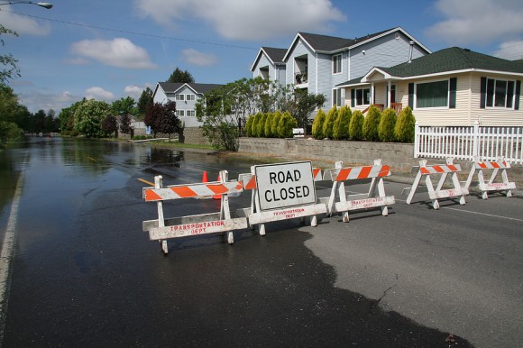
Climate change is being felt in many coastal communities of the United States, not always in the form of big weather disasters but as a steady drip, drip, drip of nuisance flooding.
According to researchers at the University of California, Irvine, rising sea levels will cause these smaller events to become increasingly frequent in the future, and the cumulative effect will be comparable to extreme events such as Hurricane Katrina or Superstorm Sandy.
“Catastrophic storms get a lot of media attention and are studied, but we wanted to know more about the non-extreme events,” said Amir AghaKouchak, UCI associate professor of civil & environmental engineering and co-author of a new study on cumulative hazards in the American Geophysical Union journal Earth’s Future.
“These diffuse floods happen multiple times a month or year,” he said. “They don’t kill anyone, they don’t damage buildings, but over time they have extremely high-cost outcomes, and it happens without us realizing it.”
In Washington, D.C., for instance, the number of hours of nuisance flooding per year has grown from 19 between 1930 and 1970 to 94 over the last two decades. Projections suggest that there could be as many as 700 hours of nuisance flooding per year by 2050. The capital’s monuments, marinas, parks, public transportation infrastructure, roads and businesses could be affected.
The UCI researchers found similar potential impacts in four other American cities: Miami, New York, Seattle and San Francisco.
Full Moon
Climate change is driving the growth of cumulative hazards, according to the UCI researchers. A full moon on a clear night triggering higher tides is now enough to cause flooding, because ocean levels are so high.
“The frequency is increasing because of sea level rise,” AghaKouchak said. “We call it clear-sky flooding. There’s no rain, but if you have a higher-than-usual tide, you get flooding in these coastal areas.”
While not catastrophic at the time, these episodes degrade infrastructure and can damage roads and building foundations. More immediately, nuisance flooding forces municipalities to expend resources to pump water out of streets. Communities suffer school closures, traffic interruptions, and reverberating waves of cost and inconvenience. Degraded sewer infrastructure results in heightened public health risks.
Lead author Hamed Moftakhari, a UCI postdoctoral scholar, said that people in often-hit regions have begun the process of adapting to the problem.
“In a recent social science survey, people weren’t really interested in knowing the depth of the water. They just wanted to know how long they would be flooded,” he said. “Their main concern was finding out when they could get back to their schools and businesses.”
But public officials can’t afford to take cumulative hazards in stride, said co-author Richard Matthew, UCI professor of planning, policy and design. Policymakers faced with limited capital funds frequently defer action or make incremental improvements when major investments may be critical to fortify their communities.
Hazard Index
The team created a cumulative hazards index to pinpoint which locations would experience the greatest long-term risk.
“This index gives officials a tool that could help them decide to move beyond the convenient but potentially very costly strategies of deferral and incrementalism and promote more transformative policies where they make sense,” Matthew said.
Co-author Brett Sanders, UCI professor of civil and environmental engineering, said the index is particularly useful for “predicting future hot spots for nuisance flooding across the U.S., where adaptation measures are needed the most.”
Funding for the study was provided by the National Science Foundation. Data was provided by the National Oceanic & Atmospheric Administration and Climate Central.
In related research, the National Oceanic and Atmospheric Administration (NOAA) has reported that nuisance flooding caused by rising sea levels has increased on all three U.S. coasts between 300 and 925 percent since the 1960s.
Also, the Union of Concerned Scientists (UCS) analyzed 52 NOAA tide gauges in communities from Portland, Maine to Freeport, Texas in 2014, using moderate sea level rise projections. In the next 15 years, most of the towns analyzed could see a tripling in the number of high-tide floods each year and, in 30 years, a ten-fold increase compared to historic levels, according to the analysis.
Source: Cumulative Hazard: The Case of Nuisance Flooding
Related:
- Nuisance Flooding Rising Problem for U.S. Cities: NOAA
- High-Tide Floods to Triple for Some East Coast Cities, Study Finds
- How Flood Risk in U.S. Is Changing: Increasing in North, Decreasing in South
Topics Flood
Was this article valuable?
Here are more articles you may enjoy.
 CFC Owners Said to Tap Banks for Sale, IPO of £5 Billion Insurer
  Former Broker, Co-Defendant Sentenced to 20 Years in Fraudulent ACA Sign-Ups
  Judge Tosses Buffalo Wild Wings Lawsuit That Has ‘No Meat on Its Bones’