
PERILS AG, the independent Zurich-based company that provides industry-wide catastrophe
insurance data, announced the release of satellite-based flood footprints for the ongoing floods in Central Europe, concentrated on Germany, Austria and the Czech Republic.
PERILS said the images “will update over the duration of the floods, are based on radar and optical satellite data, and cover the Danube and Vltava-Elbe river basins.
“Daily flood snapshots will be produced to facilitate the immediate assessment of the possible impact of the events. In addition, after the floods, a map showing the maximum extent of the flooding will be produced.
“The flood footprints are in a geo-coded format and can be easily combined with other geo-coded data such as insured exposure information. The images are part of the trial phase of a project to provide satellite-based flood footprints to the insurance industry and are sponsored by the European Space Agency.”
In addition the bulletin explained that then map data are produced by SERTIT and Vista, companies who provide remote sensing services. PERILS acts as the distribution platform for the data.
Eduard Held, Head of Products at PERILS, commented: “We sincerely hope that the flood footprint information provided by PERILS will assist the industry in managing the consequences of the flood events currently impacting Central Europe. Our aim is to provide data which is of high relevance to the industry as a whole and which contributes to the better management and understanding of natural catastrophe risk.”
Source: PERILS
Was this article valuable?
Here are more articles you may enjoy.
 Models Stripped of Insurance Cover for Club’s Unauthorized Use of Their Images
  Allstate’s $1.7M RICO Claims Fraud Suit Merits Trial, Not Arbitration: NJ High Court
  Florida Appeals Court Strikes Jury’s $335,000 Award in Universal Plumbing Claim
 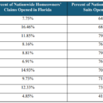 Florida’s Share of Claims Lawsuits Now About Half of 2020 Numbers, Data Show