
Hurricane Erin will likely become even larger as it churns past the Bahamas, avoiding land but raising the risk of high winds and flooding hundreds of miles away along North Carolina beaches.
Erin’s top winds measured at 140 miles (225 kilometers) per hour Monday, making it a Category 4 storm on the five-step, Saffir-Simpson scale, the US National Hurricane Center said in an advisory at 5 p.m. New York time.
The hurricane — the first of the six-month Atlantic season — was 695 miles (1,120 kilometers) southwest of Bermuda, moving northwest at about 10 mph (17 kph). Heavy rain was forecast through Tuesday for Turks and Caicos, Hispaniola — which includes Haiti and the Dominican Republic — and the eastern Bahamas.
If Erin holds to its forecast track, it will avoid a direct strike on any of the islands in the area or the US East Coast. It’s expected to trace a shallow, C-shaped arc through the western Atlantic, passing between North Carolina and Bermuda overnight Wednesday into Thursday.
While Erin won’t directly hit East Coast states, residents on the shoreline will know the storm is passing by, the National Weather Service said. Dangerous surf, flooding and beach and coastal damage are expected in North Carolina, where local officials have begun ordering tourists and residents to evacuate from some Outer Banks barrier islands.
“Numerous roads will likely be impassable under several feet of water and vehicles will likely be submerged,” the National Weather Service said in a briefing, adding that flooding could begin in North Carolina as soon as Tuesday.
In coastal Dare County, North Carolina, crews have begun removing lifeguard stands and trash cans from local beaches and fortifying sand dunes to keep heavy waves from washing them away.
Storm surge — combined with local tides — could cause water to rise up to four feet (1.2 meters) above the ground, the weather service said, with a chance of winds gusting up to 45 mph by Wednesday evening.
Coastal flooding and rip currents also are expected in several other states, including from Virginia and Florida north to New York, where waves may crest more than 20 feet on Long Island Thursday and Friday.
New Jersey Gov. Phil Murphy said in an X post Monday conditions are expected to deteriorate along the Jersey Shore.
“We urge residents and visitors to avoid wading and swimming in the ocean, especially when lifeguards are off duty,” Murphy said.
Erin’s winds increased rapidly over the weekend to reach 160 mph, making it a scale-topping Category 5 storm and one of the earliest examples of such a powerful system to emerge in the Atlantic this year. In July 2024, Beryl became the earliest hurricane to reach top intensity during the Atlantic season.
Erin’s hurricane-strength winds stretch 80 miles from its center and tropical-storm-strength winds of 39 mph to 73 mph reach out 230 miles, or slightly larger than the distance between Washington and New York City.
Erin’s top winds may still edge upward as the storm travels over warm waters that can provide additional fuel. But given “the less conducive shear over the system, not much additional strengthening is likely,” US Senior Hurricane Specialist Richard Pasch wrote in a forecast analysis.
While Erin barely grazed Puerto Rico and the Virgin Islands, it still knocked out power to many residents. By Monday afternoon, about 6% of Puerto Rico residents were without power, Luma Energy reported.
Tropical storm warnings have been posted for the Turks and Caicos Islands, as well as the southeastern Bahamas.
Peak Approaching
Another tropical wave that bears watching is moving off Africa into the Atlantic, said Dan Pydynowski, a meteorologist with commercial forecaster AccuWeather Inc.
The patch of thunderstorms and showers was near Cabo Verde off the African coast and moving west across the Atlantic, with a 60% chance of becoming a storm in the next week.
That part of the ocean, between the Caribbean and Africa, is known as the main development region to forecasters and it’s where some of history’s most deadly and damaging storms have formed. It’s also a part of the ocean that becomes particularly active between mid-August and late September.
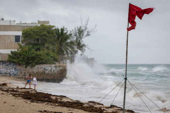
Photograph: A ripped red flag warning of rip current waves as Category 5 Hurricane Erin approaches in San Juan, Puerto Rico, on August 16, 2025; photo credit: Ricardo Arduengo/AFP/Getty Images
Topics USA Catastrophe Natural Disasters Hurricane
Was this article valuable?
Here are more articles you may enjoy.
 Clash of Florida Titans Pits Powerful Tribe Against Homebuilder Lennar
  Farmers to Pay $2.8M to Settle TPCA Class Action Lawsuit
  El Niño Likely Strongest in 75 Years, US Forecasters Say
  Shark Attack on Alabama Teen Inspires Start of National Alert System