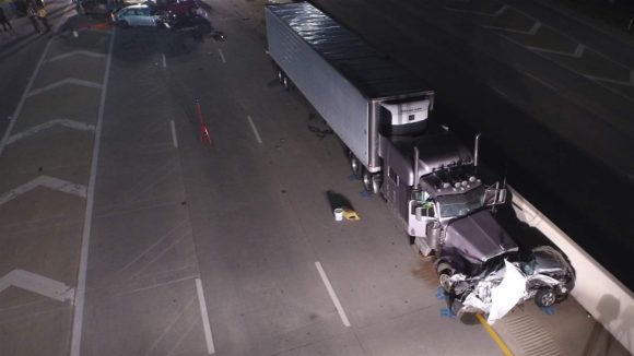
When police investigators tried to figure out what caused a multi-vehicle crash that killed an elderly woman in Morton, Illinois, last month, they looked to the sky for help.
Like a growing number of police agencies throughout the country, the sheriff’s office in Tazewell County relied on a drone to quickly take photographs of the scene from on high to help investigators reconstruct the crash.
“It’s about a hundred times more detailed than what we could do with people taking the measurements,” Chief Deputy Jeff Lower said. “And it means that there’s much less time for the road to be closed and traffic to be backed up.”
For decades, police investigators at crash scenes used chalk marks, tape measures and roller-wheels to record measurements and skid marks to help them assess what happened. More recently, many have used a laser scanning tool to map the scene. But often, those measurements can take hours, during which lanes may need to be shut down or the road closed entirely, putting emergency responders and crash investigators in harm’s way near traffic whizzing past.
Now, more police agencies are turning to drones, unmanned aerial vehicles, to do that work. Remote pilots send up the drones, which take high-resolution photos that are fed into a computer and run through software. That creates 3D models that piece everything together for investigators.

And while privacy and civil rights advocates strongly oppose law enforcement using drones for mass surveillance, such as at a protest rally, or for gathering criminal evidence without a warrant, they generally are not as concerned when it comes to car crashes.
“Filming a traffic accident overhead to get a better view, if it’s strictly limited to that purpose, is not the sort of thing that we would necessarily object to,” said Chad Marlow, a senior counsel at the American Civil Liberties Union in New York.
Jeramie D. Scott, national security counsel for the Electronic Privacy Information Center, a Washington, D.C.-based nonprofit research group, agreed that it is “less likely” his group would be concerned about using drones for crash reconstruction, as long as there wasn’t some type of surveillance involved in collecting information about individuals.
“The risk,” Scott said, “is that without rules protecting privacy, law enforcement will use drones to conduct surveillance, including general surveillance of groups.”
Police Drone Use Grows
State and local emergency response agencies use drones in a variety of ways, from tracking wildfires to search and rescue missions.
At least 910 state and local police, fire and emergency services agencies have drones, according to an estimate by the Center for the Study of the Drone at Bard College in New York. And those numbers have skyrocketed — up 82 percent from 2016 to 2017. About two-thirds of the agencies with drones are in law enforcement.
While the study doesn’t break out how many police agencies use drones specifically for crash reconstruction, Dan Gettinger, co-director at the center, said the idea is spreading.
Lower, of the Tazewell sheriff’s office, said his department started using drones about a year ago for accident reconstruction, and has deployed them in six crashes. It has spent about $15,000 for the program, including training.
In the recent crash that killed the elderly woman, Lower said it took only 45 minutes to gather information using a drone, rather than the three hours it would have taken on the ground. The woman’s car hit the rear of a semi tractor-trailer stopped at a light and the side of another vehicle nearby. She died at the scene.
Last year, North Carolina’s transportation department and highway patrol conducted a real-life drone study using a simulated two-car crash. It took the reconstruction team an hour and 51 minutes to collect the data using a laser scanner. It took 25 minutes using drones.
Using drones for crash reconstruction also can reduce staff time, some officials say.
Maine state police bought three drones for reconstruction last year and have used them more than 30 times to investigate crashes. They paid about $40,000 for the drones, software and training. “We’ve probably saved twice that in overtime alone,” said Lt. Bruce Scott, the traffic safety unit’s commander.
Drone Controversy
Drones can be controversial, and many states have passed legislation to regulate or restrict their use.
At least 18 states require law enforcement agencies to get search warrants to use drones for surveillance or conducting a search, according to the National Conference of State Legislatures.
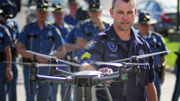
But some of those states have specifically exempted crash reconstruction. In Maine, for example, state police worked with legislators to make sure the exemption was included in drone legislation enacted in 2015, according to Maine State Police Sgt. Darren Foster, who oversees his agency’s drone program.
In Virginia, the Stafford County Sheriff’s Office wanted to start a drone crash reconstruction program but was hampered by a state law requiring police to get a warrant to use a drone except in certain circumstances, such as Amber Alerts for missing children.
Earlier this year, the sheriff’s office contacted Republican state Del. Bob Thomas, who introduced a bill allowing drones for crash reconstruction without a warrant.
The Legislature unanimously passed the measure, which was signed into law by Democratic Gov. Ralph Northam in March. It went into effect in July.
While the program has just started, Stafford County Capt. Ben Worcester said he expects it to revolutionize the way investigators capture crash scene evidence and help protect emergency workers and the public.
“The benefits are undeniable,” he said.
Source: Stateline, an initiative of The Pew Charitable Trusts.
Topics Auto Agencies Law Enforcement Drones Maine
Was this article valuable?
Here are more articles you may enjoy.
 Insurers Must Defend Hotels Accused of Sex Trafficking of Minors
  Viewpoint: Who Gets Credit for Successful Renewal During Soft Reinsurance Market?
  eBay Settles Couple’s Harassment, Stalking Claims for $55.7 Million
  Bill to Curb Staged Accidents Introduced in Senate