

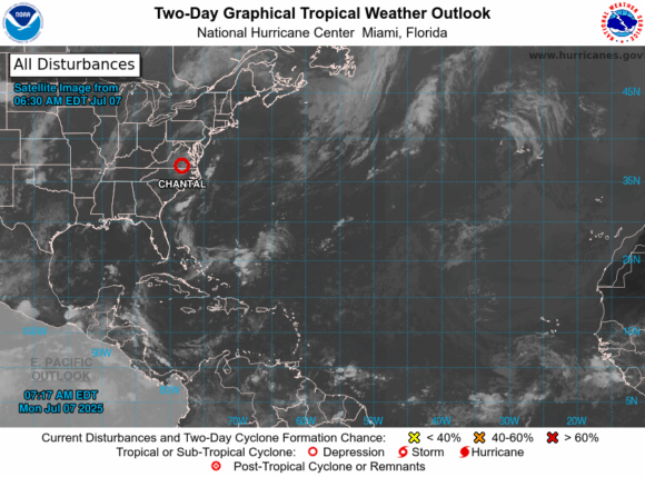
MIAMI (AP) — Tropical Storm Chantal was downgraded to a depression Sunday but raised concerns of possible flash flooding as it makes its way through central North Carolina toward south-central Virginia.
Chantal made landfall near Litchfield Beach, South Carolina, at about 4 a.m. EDT Sunday, the National Hurricane Center in Miami said. At 5 p.m., it was located about 65 miles (105 kilometers) south-southwest of Raleigh, North Carolina, and was moving north-northeast at 10 mph (17 kph) with maximum sustained winds of 30 mph (45 kph).
The system was expected to turn more to the northeast late Sunday as it weakens over North Carolina but may strengthen slightly as it approaches the Virginia Capes on Monday. Flood watches were issued for central North Carolina and south-central Virginia through Monday, with total rainfall of 2 to 4 inches (5 to 10 centimeters) and local amounts up to 6 inches (15 centimeters) that could lead to flash flooding, the hurricane center said.
Forecasters said dangerous surf and rip currents at beaches from northeastern Florida to the mid-Atlantic states are expected to last for the next couple of days.
Was this article valuable?
Here are more articles you may enjoy.
 Two Past Hurricanes, OIR Data Give Idea of What to Expect From Isaias in Florida
  TSMC Mulls Multibillion-Dollar Texas Site for More AI Chips
  NY City Accuses Law Firm of Running Injury Claims Fraud Operation
  Agency Duties – Legal vs. Ethical

