Poverty and climate hazards make the southeast United States the country’s most vulnerable area to climate change impact, Oxfam America said.
A report released by the relief organization identified high-risk “hotspots” across 13 southeast states from Arkansas to Virginia where poverty factors combined with high risk of drought, flooding, hurricanes and sea-level rise.
“Social factors like income and race do not determine who will be hit by a natural disaster, but they do determine a population’s ability to prepare, respond, and recover when disaster does strike,” Oxfam America President Raymond Offenheiser said.
“As climate change increases and intensifies floods, storms, and heat waves, many of the world’s poorest communities, from Biloxi (Mississippi) to Bangladesh, will experience unprecedented stress,” Offenheiser added.
Oxfam said the study, using a method developed by the University of South Carolina’s Hazards and Vulnerability Research Institute, for the first time overlaid risk of climate hazards with social variables.
It was released when the Obama administration is trying to push a climate change bill through Congress ahead of a United Nations summit in December.
The report includes maps that depict different levels of social and climate change-related hazard vulnerability in the U.S. southeast, which accounts for roughly 80 percent of all U.S. counties that experience persistent poverty.
For example, one identified high-risk area was Iberia Parish in Louisiana, which had some of the highest hazard exposures – 76.8 percent of land in a flood zone, 78.9 percent in the extreme drought zone, 56 percent in a sea-level rise zone, and all within a hurricane wind zone. It also had some of the highest social vulnerability scores, due to its growing Latino population with young children, racial inequalities, and dependencies on industries like fishing, oil and gas.
“Given Iberia’s propensity to climate disaster and high social vulnerability, most of the families there will be negatively affected if any one of the climate risks occurs,” the report said.
Poor families were among the worst affected when Hurricane Katrina devastated New Orleans in 2005.
Miami-Dade County in Florida was also qualified by the report as a high-risk area, whose social vulnerability was reflected in the prevalence of households headed by women earning low wages, and large communities of immigrants, many of them poor. Miami-Dade has high numbers of Haitian, Cuban and other Caribbean immigrants.
Overlaid onto this was Miami-Dade’s high climate hazard exposure – half of the county lies within a flood zone, 40 percent is in an extreme drought zone, 38 percent is at sea-level rise risk, and all of it is in a hurricane zone.
Coastal counties suffering from both high exposure and high social vulnerability include coastal south Texas, portions of south Louisiana, western Florida north of Tampa, western Alabama, and the coastal plains of South Carolina.
Was this article valuable?
Here are more articles you may enjoy.
 Premiums Will Skyrocket by 2035; Discounts Not Enough for Wind Mit, Studies Say
  Honda’s Insurance Agency Operations Stall, Services ‘Paused’
 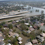 20 Years After Hurricane Katrina: Are Insurers Ready for a Different $100B Disaster?
  Clash of Florida Titans Pits Powerful Tribe Against Homebuilder Lennar
 From This Issue