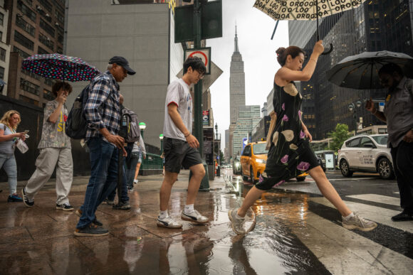
Thunderstorms disrupted New York City transit and inundated roads just as workers started their the home-bound commute Thursday, but conditions were improving into the night and Friday morning commuters can likely expect smoother journeys.
All flash flood warnings in New York have been lifted, and remaining warnings for a stretch of the Jersey shore are set to end later Thursday evening. Skies in New York City are predicted to clear through Friday as high pressure builds in from the northwest, with temperatures topping out around 75C (24C), the National Weather Service said.
Weather conditions were expected to stabilize through the night, with the National Weather Service’s New York and Philadelphia/Mount Holly offices both noting in evening bulletins that the frontal boundary responsible for the rains and thunderstorms was shifting farther south.
Amtrak restored rail traffic between Philadelphia and Wilmington, having earlier suspended service due to high water over tracks, and the Clearview Expressway reopened after rush hour flooding blocked all lanes through northern Queens. However, service on the Long Island Railroad remains suspended between Penn Station in Manhattan and Port Washington, with delays reported on another line. More than 800 flights were canceled to and from JFK, LaGuardia and Newark airports as of Thursday evening, according to FlightAware.
Earlier on Thursday, New York Governor Kathy Hochul declared a state of emergency for the city and surrounding counties, while New York City Mayor Eric Adams advised residents to avoid unnecessary travel and evacuate basement and ground-floor apartments prone to flooding. All 21 counties in New Jersey are also under a state of emergency. This is the second time this month that torrential downpours in New York City and the surrounding region have snarled transit and air travel.
The National Weather Service received scattered reports of flooding from Greenwich Village in Manhattan to the Staten Island Expressway, according to meteorologist Joe Pollina. As the storm pushed east Thursday evening, rain was expected to continue in Brooklyn and Queens into Long Island.
“It is ramping down a little across certain areas, but the damage has already been done,” Pollina said.
The Metropolitan Transportation Authority also halted service on multiple lines beginning Thursday morning as crews investigated a loss of electricity to signals near West 4th Street-Washington Square in Manhattan. Other lines were delayed as trains rerouted or skipped stops to avoid the outage.
Life threatening flooding occuring in northern Queens near Bayside. Multiple cars fully submerged. STAY OFF THE ROADS. pic.twitter.com/0YyyzJsJ22
— Empire Weather | Andrew Sirota (@Empire_Weather) July 31, 2025
Thursday’s rain threatens to flood subways, streets and low-level apartments and storefronts, while high winds from the storm could trigger power outages. Downpours were expected to fall at rates of 2 inches (5 centimeters) per hour and total as much as 5 inches in some areas, the National Weather Service said. Washington was also expecting downpours, with flood watches in effect from Connecticut to Virginia.
More than 43 million people were at risk of flash flood impacts in the Northeast, according to commercial forecaster AccuWeather.
Photo: Pedestrians during a rainstorm in New York, US, on Thursday, July 31, 2025. New York City commuters are bracing for potential flooding from heavy rain Thursday, just hours after an unrelated power outage that continued to snarl subways late into the afternoon.
Topics Flood New York New Jersey
Was this article valuable?
Here are more articles you may enjoy.


 Plane Crashes in Texas Hill Country, Killing 5 Pickleball Players
  Florida Woman Drives Elevated Pickup Over Lamborghini Sports Car in Parking Lot
  Study Suggests Federal Action to Realize Insurance Savings
  No, Florida Lawmakers Did Not Repeal the No-Fault Auto Insurance Law

