New York is upgrading its statewide system that helps communities better understand and predict flooding so that they can reduce the associated risks.
FloodSafe NY is a partnership between the state’s Department of Environmental Conservation (DEC) and the U.S. Geological Survey (USGS) to develop a first-in-the-nation statewide hydrologic monitoring network. FloodSafe NY aims to give flood-prone community access to the water data needed to identify flooding patterns and hydrologic trends.
The Hochul Administration says the improved technology will help communities save lives and reduce damage from future flooding events by anticipating flood risks earlier and making smarter infrastructure decisions.
The program will modernize the state’s streamgage network, a connected system of monitoring stations that measure water levels and the flow rate of rivers, streams, and lakes. The existing streamgages will be upgraded with camera technology, backup data transmission and two-way telemetry to improve functionality. Streamgages will be placed in high-priority locations for flood warning, and virtual streamgages will be deployed in data-sparse areas.
“As climate change increases the frequency and intensity of flooding, New York State is making historic investments to make our infrastructure more resilient to extreme weather,” Governor Kathy Hochul said.
According to DEC Commissioner Amanda Lefton, FloodSafe NY will produce more accurate flood warnings that can save lives and reduce property damage.
FloodSafe NY is funded by the Clean Water, Clean Air and Green Jobs Environmental Bond Act and USGS matching funds.
New York is also implementing a $4.2 billion Environmental Bond Act to support communities with funding for nature-based infrastructure like green roofs, permeable pavement and restoring natural habitats to help reduce stormwater runoff and mitigate flooding.
Water Supply
In addition to providing near real-time data on what is happening in streams and rivers, officials said the improvements promise to provide water data necessary to monitor drought conditions, ensure adequate clean water supplies, improve water-resource policy, and fuel economic development.
According to USGS, nearly about 8% of the U.S. population live in areas where water demand consistently approaches or exceeds naturally available water supply. In April, USGS launched the USGS National Water Availability Assessment Data Companion which provides detailed information about water supply and demand across approximately 80,000 watersheds nationwide.
“While the United States has abundant water nationally, regional imbalances between supply and demand may create water challenges affecting millions of Americans,” said Shirley Leung, lead USGS scientist. “This tool can help decision-makers understand whether challenges may stem from limited natural water supply, high demand, or both. This information is helpful for effective water planning.”
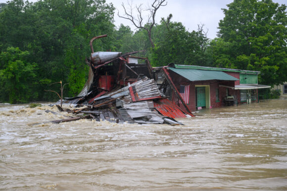
Photo: A property near the intersection of Route 9J and U.S. Route 1 is battered by floodwaters on Wednesday, July 29, 2026, in Castleton, N.Y., after torrential rainfall triggered widespread flooding across the region. (Jim Franco/The Albany Times Union via AP)
Was this article valuable?
Here are more articles you may enjoy.
 Gulf Coast on Alert for First Hurricane of 2026
  Hurricane Isaias Reaches Cat 3 Status as Insurers, Adjusters, Property Owners Prepare
  McDonald’s Hit With Class Action Alleging AI-Powered Menu Price-Fixing
  Karen Clark Rolls Out Severe Convective Storm Model 5.0

