
Some Minot residents who endured the Souris River flood of 2011 are having trouble digesting the current snowpack numbers.
The National Weather Service says the snowfall total in the city for November and December is approaching 43.5 inches, which is more than an inch above the total for the same two months in 2010. A few months later, flooding destroyed thousands of homes and other structures in Minot and caused an estimated $1 million in damage in the region.
But weather service hydrologist Alan Schlag tells the Minot Daily News that it’s too early to get a handle on spring flooding. He said the 2011 flood was produced not by the snowpack alone, but in combination with spring rains.
“There’s definitely a multitude of things that have to go into creating a flood,” Schlag said. “First and foremost you have to have water, and it doesn’t necessarily have to come from the snowpack.”
Heavy snowfall has also been recorded over the Des Lacs River Basin. The Des Lacs is subject to rapid runoff because it is situated in a valley with numerous deep coulees leading directly to the river. The Des Lacs enters the Burlington Project area before joining the Souris River and continuing into Minot.
“If there’s a river system that has my attention more than any other, it is the Des Lacs,” said Schlag. “There’s no dampening on the Des Lacs. If there’s a risk of springtime flooding right now, it’s the Des Lacs. It has just a ton of coulees.”
Schlag also notes that August and September were wet in North Dakota and Saskatchewan.
“The end of November storm came with rain and a lot of snow on warm ground. We wetted up our soils into the 90 percentile. That’s not conducive to snowmelt runoff in spring.”
Topics Flood
Was this article valuable?
Here are more articles you may enjoy.
 Robotaxi Riders Are Falling Asleep, Sparking Frantic 911 Calls
  After Losing Job and Crypto, Man Falsely Claimed $1.3M From 107 Class Actions
 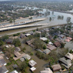 20 Years After Hurricane Katrina: Are Insurers Ready for a Different $100B Disaster?
  Fla. Supreme Court Reverses Lower Court on Compensability of a Workplace Shooting