
The Missouri Department of Commerce and Insurance released preliminary uninsured estimates for properties in the St. Louis in response to the F3 tornado that struck the region on Friday, May 16.
DCI Department Director Angela Nelson said the department collects information from the insurance industry about the policies issued within the state but doesn’t have data on the exact number of uninsured homes affected by the tornado.
The 23-mile long tornado affected approximately 5,000 properties and caused an estimated $1 billion in damages, city officials have said. The tornado initially touched down in Clayton, then tracked northeast through parts of North County and into Illinois.
“During my visit to St. Louis on Tuesday, I received multiple requests not only about data for the number of insured homes and renters we had in the impacted area but also about the number of uninsured,” said Nelson. “While information about uninsureds isn’t available, the department wanted to provide assistance to policymakers assessing community needs.”
Nelson said the department was able to make a rough estimate of how many potentially uninsured homes and renters there may be based on the department’s zip code collection data.
“While this number is certainly not exact; it is fluid and subject to change, it does provide a general picture of what we may be dealing with in terms of uninsured losses,” Nelson said.
The most heavily uninsured areas are in North County zip codes 63115, 63107, and 63113, DCI shared. The estimates includes both homeowners and renters. DCI said it estimates that approximately 90% of the renters in these zip codes could be uninsured, while the number of uninsured homes could be around 67%.
DCI said significant uninsured areas are in the more densely populated zip codes of the North Riverfront area of 63147, the Central West End neighborhood of 63108, and the West End/Skinker DeBaliviere and DeBaliviere Place neighborhoods of 63112. Approximately 63% of renters in these areas could be uninsured, while around 49% of homeowners could be uninsured, DCI said.
Additionally, the zip codes of Richmond Heights 63117; the St. Louis neighborhood associated with 63110 that includes Forest Park, Shaw, The Hill, Central West End, and Cheltenham; and Clayton’s 63105 neighborhood have lower uninsured numbers of renters and homeowners, DCI said.
Missouri’s data collection includes only carriers with greater than 500 annual exposures, which only covers about 88% of the homeowner’s market, the department said.
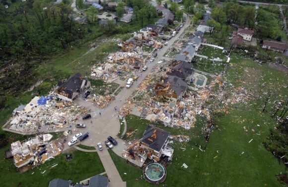
Photo: In this aerial photograph, debris is strewn about a neighborhood Saturday, April 23, 2011, in Bridgeton, Mo., following a Friday-evening tornado in the area. St. Louis’ main airport was closed for business Saturday while crews cleaned up after a tornado tore through a terminal, causing several injuries and sending people scurrying for shelter as plated glass shattered around them. (AP Photo/Jeff Roberson)
Was this article valuable?
Here are more articles you may enjoy.
 Bill to Curb Staged Accidents Introduced in Senate
  Google Ordered to Defend Robby Starbuck’s AI Defamation Suit
  As US Residential Solar Industry Craters, Florida Bucks Trend
  Jury Awards 78-Year-Old Victim $56 Million for Crash Caused by Amazon Delivery Driver