
NASA’s first radar images from a new Earth-mapping satellite show the Maine coast and North Dakota farmland in incredible detail.
The pictures, released Thursday, are from a spacecraft that rocketed into orbit from India two months ago.
The joint U.S.-Indian mission, worth $1.3 billion, will survey virtually all of the world’s land and ice masses multiple times. By tracking even the slightest shifts in land and ice, the satellite will give forecasters and first responders a leg up in dealing with floods, landslides, volcanic eruptions and other disasters.
NASA said these first pictures are a preview of what’s to come once science operations begin in November.
The satellite, flying 464 miles (747 kilometers) high in a near polar orbit, is called NISAR, short for NASA-ISRO Synthetic Aperture Radar. ISRO is the Indian Space Research Organization.
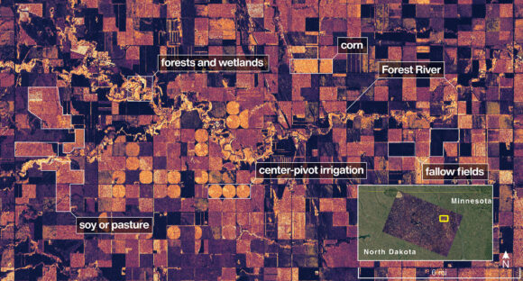
This image provided by NASA/JPL-Caltech on Aug. 23, 2025, NISAR imaged land adjacent to northeastern North Dakota’s Forest River, light-colored wetlands and forests line the river’s banks, while circular and rectangular plots throughout the image appear in shades that indicate the land may be pasture or cropland with corn or soy. (NASA/JPL-Caltech via AP)
Topics Agribusiness Aerospace Maine
Was this article valuable?
Here are more articles you may enjoy.
 Allstate’s $1.7M RICO Claims Fraud Suit Merits Trial, Not Arbitration: NJ High Court
  Husband and Wife Insurance Brokers Sentenced for Fraud Scheme
  Two Years in, Ortiz Steps Down as CEO of Florida Re
  Gallagher’s RPS Acquires W.N. Tuscano Agency, a Pennsylvania MGA