

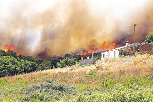
A report issued today shows 4.5 million U.S. homes at high or extreme risk of wildfire as the multi-year drought continues.
The report’s author said the worsening drought means 2015 has the potential to be one of the most devastating wildfire seasons on record.
Verisk Insurance Solutions released its 2015 FireLine State Risk Reports on Wednesday. The report summarizes wildfire risk in 13 wildfire-prone states in the West and South Central U.S., and it includes three states not in past reports: Montana, Oklahoma and Wyoming.
California ranks first for the highest number of households at high or extreme risk with more than 2 million.
Texas has 706,200 homes in this category, followed by Colorado (363,900), Arizona (227,100), Idaho (163,500), Washington (157,900), Oregon (153,400), Oklahoma (148,800), Montana (130,200) and Utah (128,800).
The states with the highest percentage of households at high or extreme risk of wildfire are Montana (27 percent), Idaho (25 percent), Colorado (16.4 percent), California (15.0 percent) and New Mexico (13.9 percent).
“Worsening drought conditions in the western states indicate that 2015 has the potential to be one of the most devastating wildfire seasons on record,” Neil Spector, Verisk’s president of underwriting, said in a statement.
The number of wildfires in California alone in the first five months of 2015 is up 54 percent over the five-year average for the same time period.
“It’s more important than ever for insurers to be prepared and manage their wildfire risk effectively,” Spector said.
The reports are produced using data from FireLine, Verisk’s wildfire risk management service.
2015 Verisk Wildfire Risk Analysis
| Number of households* at high or extreme risk** | Percentage of households at high or extreme risk | ||
| 1 California | 2,054,400 | 1 Montana | 27.0% |
| 2 Texas | 706,200 | 2 Idaho | 24.5% |
| 3 Colorado | 363,900 | 3 Colorado | 16.4% |
| 4 Arizona | 227,100 | 4 California | 15.0% |
| 5 Idaho | 163,500 | 5 New Mexico | 13.9% |
| 6 Washington | 157,900 | 6 Wyoming | 13.4% |
| 7 Oregon | 153,400 | 7 Utah | 13.2% |
| 8 Oklahoma | 148,800 | 8 Oregon | 9.2% |
| 9 Montana | 130,200 | 9 Oklahoma | 8.9% |
| 10 Utah | 128,800 | 10 Arizona | 8.0% |
| 11 New Mexico | 125,100 | 11 Texas | 7.1% |
| 12 Nevada | 63,900 | 12 Washington | 5.5% |
| 13 Wyoming | 35,200 | 13 Nevada | 5.4% |
Related:
- Report: Wildfire Risk to Homes in West Tops $237B
- Effective Wildfire Prevention Hampered by Liability, Weather, Development
- Verisk Expands Wildfire Risk Service to 3 More States
Topics California Texas Catastrophe Natural Disasters Wildfire Homeowners Washington Oklahoma Mexico
Was this article valuable?
Here are more articles you may enjoy.
 Georgia, Florida Insurers Facing New Scrutiny, Regulations After Election
 Row House Fire in Brooklyn Kills 6 People and Injures 9
 Microsoft Races to Fix Outlook in One of Its Longest Outages
 Manufacturers Hammer IBHS Over 15-Year Roof Age Limit for Fortified Designation


