
An arsenal of new technology is being put to the test fighting floods this year as rivers inundate towns and farm fields across the central United States. Drones, supercomputers and sonar that scans deep under water are helping to maintain flood control projects and predict just where rivers will roar out of their banks.
Together, these tools are putting detailed information to use in real time, enabling emergency managers and people at risk to make decisions that can save lives and property, said Kristie Franz, associate professor of geological and atmospheric sciences at Iowa State University.
The cost of this technology is coming down even as disaster recovery becomes more expensive, so “anything we can do to reduce the costs of these floods and natural hazards is worth it,” she said. “Of course, loss of life, which you can’t put a dollar amount on, is certainly worth that as well.”
U.S. scientists said in their spring weather outlook that 13 million people are at risk of major inundation, with more than 200 river gauges this week showing some level of flooding in the Mississippi River basin, which drains the vast middle of the United States. Major flooding continues in places from the Red River in North Dakota to near the mouth of the Mississippi in Louisiana, a map from the National Weather Service shows.
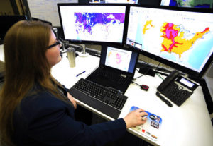
“There are over 200 million people that are under some elevated threat risk,” said Ed Clark, director of the National Water Center in Tuscaloosa, Alabama, a flood forecasting hub.
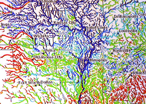
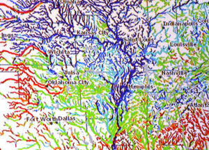
Much of the technology, such as the National Water Model , didn’t exist until recently. Fueled by supercomputers in Virginia and Florida, it came online about three years ago and expanded streamflow data by 700-fold, assembling data from 5 million river miles (8 million kilometers) of rivers and streams nationwide, including many smaller ones in remote areas.
“Our models simulate exactly what happens when the rain falls on the Earth and whether it runs off or infiltrates,” Clark said. “And so the current conditions, whether that be snow pack or the soil moisture in the snow pack, well that’s something we can measure and monitor and know.”
Emergency managers and dam safety officials can see simulations of the consequences of flood waters washing away a levee or crashing through a dam using technology developed at the University of Mississippi — a web-based system known as DSS-WISE . The software went online in 2017 and quickly provided simulations that informed the response to heavy rains that damaged spillways at the nation’s tallest dam in northern California. The program also helped forecast the flooding after Hurricane Harvey in Texas and Louisiana that year.
Engineers monitoring levees along the Mississippi River have been collecting and checking data using a geographic information system produced by Esri, said Nick Bidlack, levee safety program manager for the Memphis district of the U.S. Army Corps of Engineers. The company produces mapping tools such as an interactive site showing the nation’s largest rivers and their average monthly flow.
On the Mississippi River, flood inspectors use smartphones or tablets in the field to input data into map-driven forms for water levels and the locations of inoperable flood gates, seepages, sand boils or levee slides, which are cracks or ditches in the slopes of an earthen levee. Photos, videos and other data are sent to an emergency flood operation center in real time, allowing Corps officials to visualize any problems and their exact location, instantly informing the response, Bidlack said.
“If people in the field have concerns about something, they can let us know to go out there and look at it,” Bidlack said. “There’s a picture associated with it, a description of it, and it helps us take care of it.”
Corps engineers are increasingly flying drones to get their own aerial photography and video of flooded areas they can’t otherwise get to because of high water or rough terrain, said Edward Dean, a Corps engineer.
“We can reach areas that are unreachable,” Dean said.
The Corps also now uses high-definition sonar in its daily operations to survey the riverbed, pinpointing where maintenance work needs to be done, said Corps engineer Andy Simmerman. The Memphis district uses a 26-foot survey boat called the Tiger Shark, with a sonar head that looks like an old-fashioned vacuum cleaner and collects millions of points per square inch of data, Simmerman said.
The technology has helped them find cars and trucks that have been dumped into the river, along with weak spots in the levees.
“These areas are 20 to 80 feet underwater, we’d never get to see them without sonar,” Simmerman said. “The water never gets low enough for us to see a lot of these failures.”
During recent flooding near Cairo, Illinois, a culvert that should have been closed was sending water onto the dry side of a levee. The sonar pointed engineers to the precise location of a log that was stuck 20 feet deep in murky water, keeping the culvert open. Plastic sheathing and sandbags were brought in to stop the flow and save the land below.
“The sonar definitely made a difference,” said Simmerman. “A big success.”
Topics USA Flood Tech Mississippi Drones
Was this article valuable?
Here are more articles you may enjoy.
 Record-Low Danube Water Levels Leave Boats Beached, Reveal Decades-Old Shipwrecks
  Trump’s Diversity Crackdown Reverberates Through US Boardrooms
  AM Best Calls $1.54 Billion Mapfre-Safety Marriage ‘Strategically Compelling’
  Company at Center of Cyclospora Outbreak Complained to White House, Source Says