The National Hurricane Center’s report on Hurricane Ian, posted Monday, six months after the storm hit southwest Florida, pegs Ian as the most expensive to hit the Sunshine State, causing twice as much damage as Hurricane Andrew did 30 years earlier.
Ian, which made landfall Sept. 28 near Fort Myers, Florida, caused an estimated $113 billion in total damage in Southeastern U.S. states, according to the report from the NHC, part of the National Oceanic and Atmospheric Administration. About $109 billion of that was in Florida.
Andrew, which hit southeast Florida in 1992, resulted in about $54 billion in damage, in today’s dollars.
The total for Ian confirms some earlier estimates that have put insured losses as high as $60 billion. Ian was the third-costliest U.S. hurricane on record, behind Hurricane Katrina, which hit New Orleans and coastal Mississippi in 2005, and Hurricane Harvey, which slammed Texas and Louisiana in 2017.
![]() The NHC report gives a final look on just how powerful Ian was, and shows the perils of building in low-lying areas. It also underlines the need for property owners to secure flood insurance, even in inland parts of the state, and shows how predicting hurricanes’ paths can be tricky for some storms.
The NHC report gives a final look on just how powerful Ian was, and shows the perils of building in low-lying areas. It also underlines the need for property owners to secure flood insurance, even in inland parts of the state, and shows how predicting hurricanes’ paths can be tricky for some storms.
Some key points from the report:
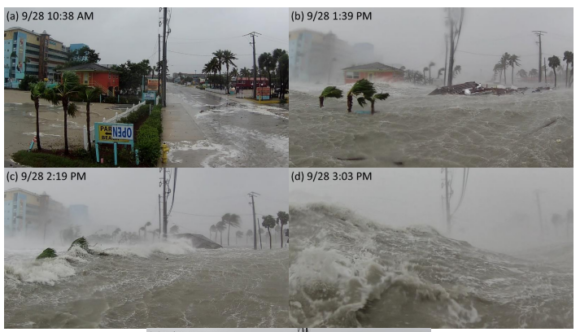
Storm surge: Ian produced a catastrophic storm surge of 10 to 15 feet on barrier islands near Fort Myers, wiping out many homes and heavily damaging others. An initial forecast had put the surge at less than 7 feet at Fort Myers Beach.
“In Fort Myers Beach alone, an estimated 900 structures were totally destroyed and 2,200 were damaged,” the report noted. “In Lee County, at least 52,514 structures were impacted, of which 5,369 were destroyed and 14,245 received major damage.”
Casualties: The storm was responsible for 156 deaths, 66 of which were directly caused by the hurricane – all of those in Florida. Storm surge was the deadliest hazard, claiming 41 lives, most of them in Lee County, which includes Fort Myers, the NHC reported.
Flooding: Ian dumped 10 to 20 inches of rain in parts of central and eastern Florida. The highest amount recorded was almost 27 inches, in Grove City, about 30 miles northwest of Fort Myers. The deluge caused widespread flooding along the St. Johns River, Lake George, Crest Lake, the Little Wekiva River and Dunns Creek and Shingle Creek. As the storm moved east, Florida’s Atlantic Coast also saw storm surge, rainfall and flooding. Daytona Beach recorded almost 21.5 inches of rain, the report indicated.
Ian damaged an estimated 4,100 structures in Osceola County and 1,656 structures in Seminole County. The Florida Department of Agriculture and Consumer Services estimated $1.1 billion to $1.8 billion in losses due to flooding and wind damage to the state’s crops and infrastructure, the report said.
Forecasts and tracking: Despite some complaints from local and state officials, who said they were caught off guard by Ian’s sudden turn to the east, the report found that errors in predicting the storm’s path were not out of the ordinary.
“The average official track forecast errors were lower than the mean official errors for the previous 5-yr period” as the storm developed, the report noted.
Consensus models, which combine data from a number of hurricane computer models, outperformed the NHC’s forecasts at some points. The best-performing model for short-term forecasts was the Florida State Superensemble. The model with the greatest track errors was the Canadian model, the report said.
“Examination of the individual official forecasts revealed the cross-track error to be the largest source of error with a consistent westward bias noted,” the report found. “While the left-of-track bias made forecasting the exact landfall location of the Ian in southwestern Florida difficult, the forecast track cone of uncertainty did contain the landfall location for all advisory cycles. In general, storms that parallel a coastline tend to be more challenging to predict because a small change in heading can cause large differences in the landfall location. Ian was an example of this particular challenge.”
Winds and pressure: Ian produced estimated peak winds of 140 knots, or about 161 mph, but the sustained winds were closer to 144 mph at landfall. That windspeed was less than that seen during some well-known storms, including Hurricane Irma, which hit much of Florida in 2017 with winds of 180 mph. Irma caused an estimated $50 billion in damages, according to reports.
The barometric pressure for Ian reached as low as 937 millibars, below the average of 950 and above Irma’s 914 mb, according to the NHC and other reports. A lower pressure is generally indicative of a more intense storm, and some meteorologists have said that pressure is a better predictor of damage than wind speed.
The NHC report was prepared by researchers Lisa Bucci, Laura Alaka, Andrew Hagen, Sandy Delgado, and Jack Beven, with the National Hurricane Center. It was posted April 3.
Top photo: Shots from a time-lapse video from a remotely operated camera during Ian at Fort Myers Beach. (Max Olson, via the NHC report)
Topics Catastrophe Natural Disasters Florida Windstorm Hurricane
Was this article valuable?
Here are more articles you may enjoy.
 Allstate Sued by Oklahoma for Alleged Scheme to Underpay Claims
  NYC to Publicly Identify Buildings Testing Positive for Legionnaires’ Bacteria
  Private Equity Turns to Heat Detectives as Climate Risks Intensify
  Ranking: Who Are the Insurance Industry’s AI Talent, Maturity Leaders?