
Nearly a decade after the deadly 2016 floods, West Virginia officials are moving forward with a study to look at flood mitigation measures across the Kanawha River Basin.
Last month, Gov. Patrick Morrisey announced that the state will work with the U.S. Army Corp of Engineers on a study that thoroughly examines flood risk management strategies across 20 West Virginia counties, most of which were impacted by the June 2016 floods.
Morrisey’s announcement comes nearly four years after the study was initially funded by the federal government.
West Virginia Sen. Shelley Moore Capito requested the study in 2016, following the deadly flooding that swept across the state and left 23 dead. Federal funding for the project was later secured in the 2021 Bipartisan Infrastructure Law.
But these types of studies require the state and federal government to split the cost equally. And the state didn’t put forward its $1.5 million share for the study until last month, indicated by Morrisey’s July announcement.
In addition to the money for the Kanawha River Basin study, the governor’s office also put $1.5 million toward the Upper Guyandotte Flood Study. That study will look at the flood risk and possible mitigation measures across Wyoming County and parts of Raleigh, which are especially vulnerable to flooding.
These two studies are the first major investments in several years by state leaders to address the growing threat of flooding, underscoring the state’s slow progress in tackling this issue.
Securing the funding spanned two Governors’ administrations, according to Morrisey spokesperson Drew Galang. He said after the Legislature allocated funds, Gov. Jim Justice’s administration worked on it and the Morrisey administration determined the final amount.
A spokesperson for Justice, who is now a U.S. senator, did not respond to questions.
West Virginia’s mountainous terrain and thousands of rivers and creeks — along with decades of strip mining and timbering — make the state especially vulnerable to flooding. This is likely to only get worse as climate change continues to increase the risk. And with an increasing frequency of floods, mitigation efforts are crucial to lessen the damage caused by them.
But it will likely be awhile before any projects stemming from the two studies are executed. Both studies are anticipated to take three years, and there’s no guarantee funding for any potential projects will be immediately available.
Capito did ensure that any project that comes out of the study of the Kanawha River Basin will only require a 10% state match — less than the typical 35%. The rest will be covered by the federal government.
The governor’s office is currently working on other flood mitigation projects in the state, including warning systems, improving drain systems and building and repairing culverts, said Galang.
“Governor Morrisey is committed to protecting West Virginians from floods and all options are on the table to best prevent and mitigate these disasters,” he said.
Lots of Plans, No Funding
In 2004, after decades of devastating floods, West Virginia officials drew up a flood protection plan that proposed several actions, including suggestions on floodplain and wastewater management as well as improved building codes and flood warning systems. But it was never implemented by state agencies.
Lawmakers revisited that plan in the aftermath of the 2016 floods and eventually tasked the State Resiliency Office, which they created in 2017, with updating the plan.
In 2023, the Legislature designated a special trust fund to help the office protect communities, especially those with low-income households, from flooding as well as to implement recommendations from its updated state flood plan, which the office completed in June 2024.
But lawmakers have never allocated money to that fund.
Robert Martin, director of the State Resiliency Office, told a legislative committee in December 2023 that there were “probably projects right now we’d be able to execute if we had what we were looking to do either with federal or state dollars.”
In his final budget proposal as governor last year, Justice asked the Legislature for $50 million for the flood resiliency fund. But as lawmakers hammered out the budget, they rejected Justice’s request, leaving the fund empty again.
As of last November, the office was still looking to secure funding.
Morrisey didn’t propose any funding for the trust in his budget earlier this year, just days before flooding in the southern coalfields. And the Legislature voted down an attempt to add money to the trust during the legislative session.
Between 2005 and 2024, West Virginia experienced nearly 2,300 floods events, costing $342 million in property damage, according to data from the National Oceanic and Atmospheric Administration’s storm events database. However, damage from smaller-scale floods is often underreported, so the actual cost may be much higher.
Nearly 200,000 West Virginians live in a high-risk flood zone, according to the West Virginia Flood Resiliency Framework created by researchers at West Virginia University.
Through their work, researchers found that the state has no long-term flood recovery plan, which has caused West Virginia’s flooding response to be inefficient.
WVU researchers also found of the nearly 100,000 buildings located in high-risk flood zones, a little more than 500 of them are considered essential. This includes fire and police stations, schools, hospitals and nursing homes.
But those findings are based on data that experts say underreports the risks.
West Virginia researchers used data and flood maps from the Federal Emergency Management Agency. While beneficial, in recent years, experts have been critical of the federal maps, saying that they’re often incomplete or out of date and don’t account for the way rain moves and pools once it falls.
While FEMA’s flood maps account for main river channels and coastal storm surge areas, they don’t model heavy rainfall — which is often the cause for flooding in West Virginia.
Under the federal maps, a little more than 9% of properties in the state are considered within the agency’s Special Flood Hazard Areas.
But under mapping by First Street Foundation, a nonprofit that studies flood risk, that tries to fill in the gaps left by FEMA, one-third of the properties in the state are at risk of flooding.
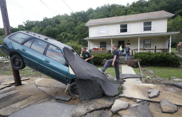
Photo: Wreckage left from the 2016 flooding in White Sulphur Springs. (AP File Photo/Steve Helber)
___
This story was originally published by Mountain State Spotlight and distributed through a partnership with The Associated Press. Reporting by Sarah Elbeshbishi.
Was this article valuable?
Here are more articles you may enjoy.
 Hellman & Friedman’s Hub International Seeks $3 Billion in IPO
  20 Years After Hurricane Katrina: Are Insurers Ready for a Different $100B Disaster?
  Remember the Fall of Patriot National? Trial in Suit vs. Mariano’s Lawyers to Begin
  Florida Property Tax Cut Plan Relies on Population Boom That Has Slowed Dramatically