
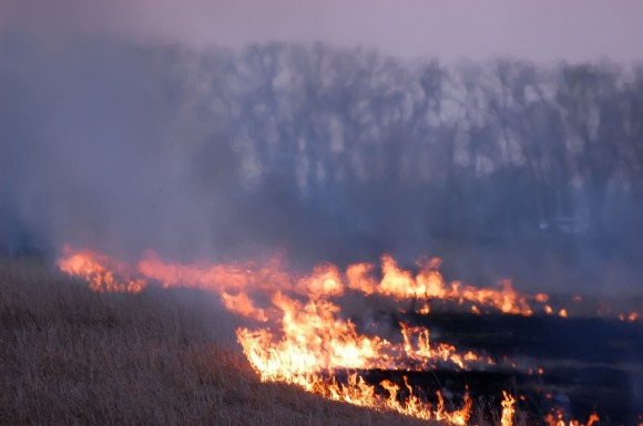
A wildfire burned out of control near homes in the dry foothills of the San Gabriel Mountains early Thursday, fanned by gusty Santa Ana winds that spit embers into neighborhoods in the city below. Evacuations were ordered for houses at the edge of the fire.
The blaze charred at least 125 acres above a neighborhood abutting a canyon of Angeles National Forest, just north of the city of Glendora roughly 25 miles northeast of downtown Los Angeles.
The Santa Anas, linked to the spread of Southern Californians worst wildfires, picked up at daybreak. The extremely dry winds blow downslope and can push fires out of the mountains and into communities below. The area, which has been historically dry, has been buffeted by the winds which have raised temperatures into the 80s.
TV news helicopters spotted embers igniting palm trees in residential yards as firefighters with hoses beat back flames lapping at the edges of homes.
Glendora police said officers were going door to door ordering residents to leave. Citrus College, located in the heart of Glendora, canceled classes for the day.
Several schools were closed. The Glendora Unified School District closed Goddard Middle School, which was being used as a fire department command post. District spokeswoman Michelle Hunter said 900 students attend the school, which is near the fire and within the evacuation area.
The Los Angeles County Fire Department deployed seven engines and three helicopters to the fire, which was reported around 5:50 a.m. (PST) and was growing rapidly. Officials added to the firefighting aircraft with a water-dropping Super Scooper plane.
Red flag warnings for critical fire weather conditions were posted from Santa Barbara County south through Los Angeles to the U.S.-Mexico border, along the spine of the Sierra Nevada, and in areas east and north of San Francisco Bay.
Large parts of Southern California below mountain passes, canyons and foothills have been buffeted all week by the region’s Santa Ana winds.
Spawned by surface high pressure over the interior of the West, the Santa Anas form as the cold air flows toward Southern California, then speeds up and warms as it descends in a rush toward the coast. Some of the most extreme gusts reported by the National Weather Service topped 70 mph.
These offshore winds also raise temperatures to summerlike levels. Many areas have enjoyed temperatures well into the 80s.
California is also under the influence of a persistent upper-level ridge of high pressure anchored off its north coast that has also kept the region generally warm, dry and clear.
Was this article valuable?
Here are more articles you may enjoy.
 Zurich CEO Says Staff Let Go as Regulator Finma Imposes Partial Sales Ban
  Trump’s Diversity Crackdown Reverberates Through US Boardrooms
  Viewpoint: Who Gets Credit for Successful Renewal During Soft Reinsurance Market?
  Company at Center of Cyclospora Outbreak Complained to White House, Source Says