
Hong Kong is bracing for widespread damage and disruption from the approaching Super Typhoon Ragasa, which is currently churning off the northern coast of the Philippines with tree-snapping winds.
The powerful storm is packing maximum sustained winds of 230 kilometers (143 miles) per hour, according to the Hong Kong Observatory, equivalent to a Category 4 hurricane on the five-step Saffir-Simpson scale. The Philippines warned of life-threatening conditions.
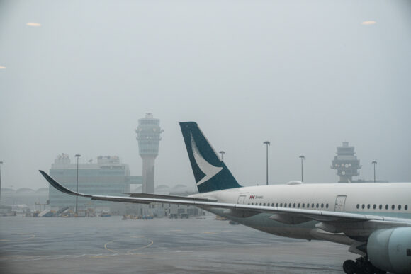
Hong Kong’s international airport is facing major disruptions due to the storm, with Cathay Pacific Airways Ltd. set to cancel more than 500 flights. Ragasa threatens to be the costliest typhoon to impact the city since Mangkhut in 2018, which led to total economic losses including insurance claims of HK$4.6 billion ($592 million), according to a tally from the weather agency.
Read more: Hong Kong Braces for Twin Storms as Forecasters Predict Super Typhoon
Schools will be suspended on Tuesday and Wednesday, while the Hong Kong exchange said it will be “closely monitoring” the typhoon — posing a potential test for the city’s push to keep markets open during severe weather.
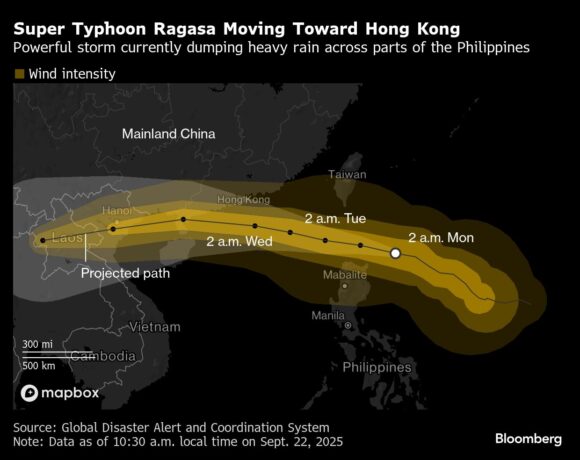
More than 10,000 people across the northern Philippines island of Luzon have been evacuated, and government work and classes were suspended in the capital Manila and several dozen provinces as of Monday. Parts of the country will get more than 200 millimeters (8 inches) of rainfall, threatening widespread flooding, damage to roads and infrastructure
Once Ragasa passes the Philippines — known locally as Nando — it will track across the South China Sea and pass to the south of Hong Kong. Gale force winds will start affecting the city on Wednesday, and could reach hurricane force strength offshore, according to the Hong Kong Observatory.
On Monday, Hong Kong was experiencing the literal calm before the storm, with blue skies and hot temperatures caused by the downward-moving air on the outer rims of the nearing typhoon. Still, local grid operators have already activated their extreme weather response plans, including pruning trees that could topple over power lines.
Upwelling of cooler deep ocean waters and friction from the jagged coastline of southern China will slow the storm’s winds slightly, but the system is still set to make landfall over Guangdong province on Wednesday as a typhoon, according to the Hong Kong Observatory.
The forecaster warned that Ragasa will likely cause significant storm surges as the typhoon approaches the city, with water levels similar to those seen during Mangkhut in 2018, a system that also blew out the windows of office buildings.
Hong Kong has already been drenched by consecutive days of rainfall over the weekend after a separate cyclone skirted close to the city. With soils already saturated and drains potentially clogged by debris, there’s a heightened risk of landslides and flash flooding when Ragasa hits.
Ragasa will be the 11th tropical cyclone to affect the city this year, breaking the record number of storm warning signals issued between January and September since 1946, according to the observatory. The typhoon will likely disrupt a two-day aviation industry conference, scheduled to begin Wednesday, that typically brings thousands of delegates to Hong Kong.
China’s Guangdong province is set to halt rail services on Wednesday, and the cities of Zhuhai and Jiangmen will suspend school and work. Shenzhen is set to evacuate some 400,000 people, according to state media.
After skirting China’s southern coast, the storm is set to make another landfall over Vietnam on Thursday as a severe tropical storm, according to the Hong Kong Observatory. Vietnam’s meteorological department has warned ships at sea of very strong winds and large waves.
Photograph: A Cathay Pacific Airways Ltd. aircraft on the tarmac at Hong Kong International Airport in Hong Kong, China; Photo credit: Lam Yik/Bloomberg
Related:
Topics Catastrophe Natural Disasters
Was this article valuable?
Here are more articles you may enjoy.
 Record-Low Danube Water Levels Leave Boats Beached, Reveal Decades-Old Shipwrecks
  Viewpoint: Who Gets Credit for Successful Renewal During Soft Reinsurance Market?
  Brown & Brown Estimates Cost of Howden-Driven Talent War Could Hit $60M in 2026
  Mapfre to Acquire Safety Insurance for $1.54 Billion in Cash Deal